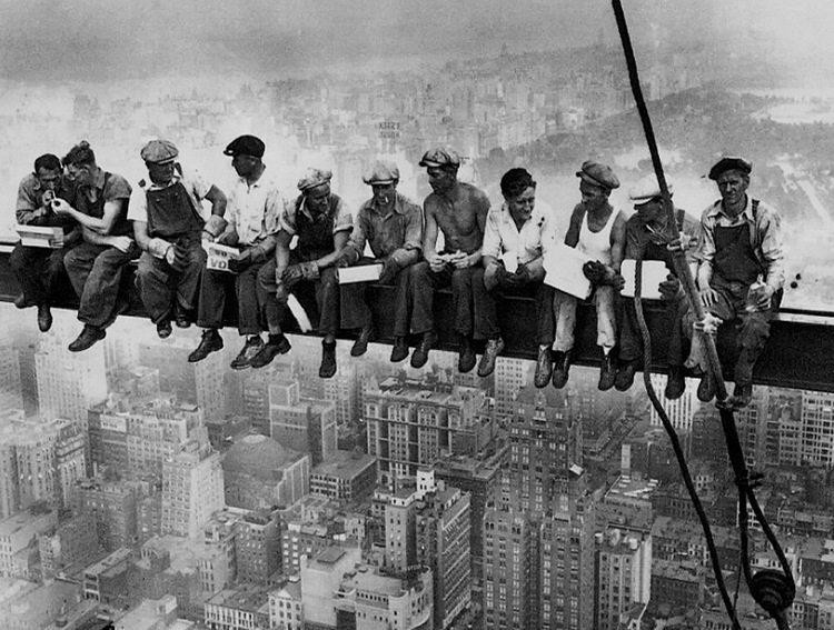
This post gathers the information I’ve been able to find about the Roswell Railroad, one of the almost-completely vanished and forgotten rail lines of the Atlanta area. This was branch of Southern Railway that operated between Chamblee and Roswell from 1881 to 1921.
The Roswell Railroad Company was incorporated in Georgia in 1879 as successor to the Atlanta & Roswell Railroad Company. It was controlled by the Atlanta & Charlotte Air-Line Railroad Company, which constructed the 10-mile, 3-foot gauge line and opened it for business on September 1, 1881. In the same year, the A&CAL was leased to the Richmond & Danville Railroad (which became Southern Railway in 1894).
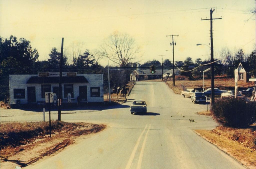
The town of Chamblee was originally called “Roswell Junction”.
However, feeling the name of the settlement was too similar to nearby Roswell, they randomly selected Chamblee from a list of petitioners for the new post office name.
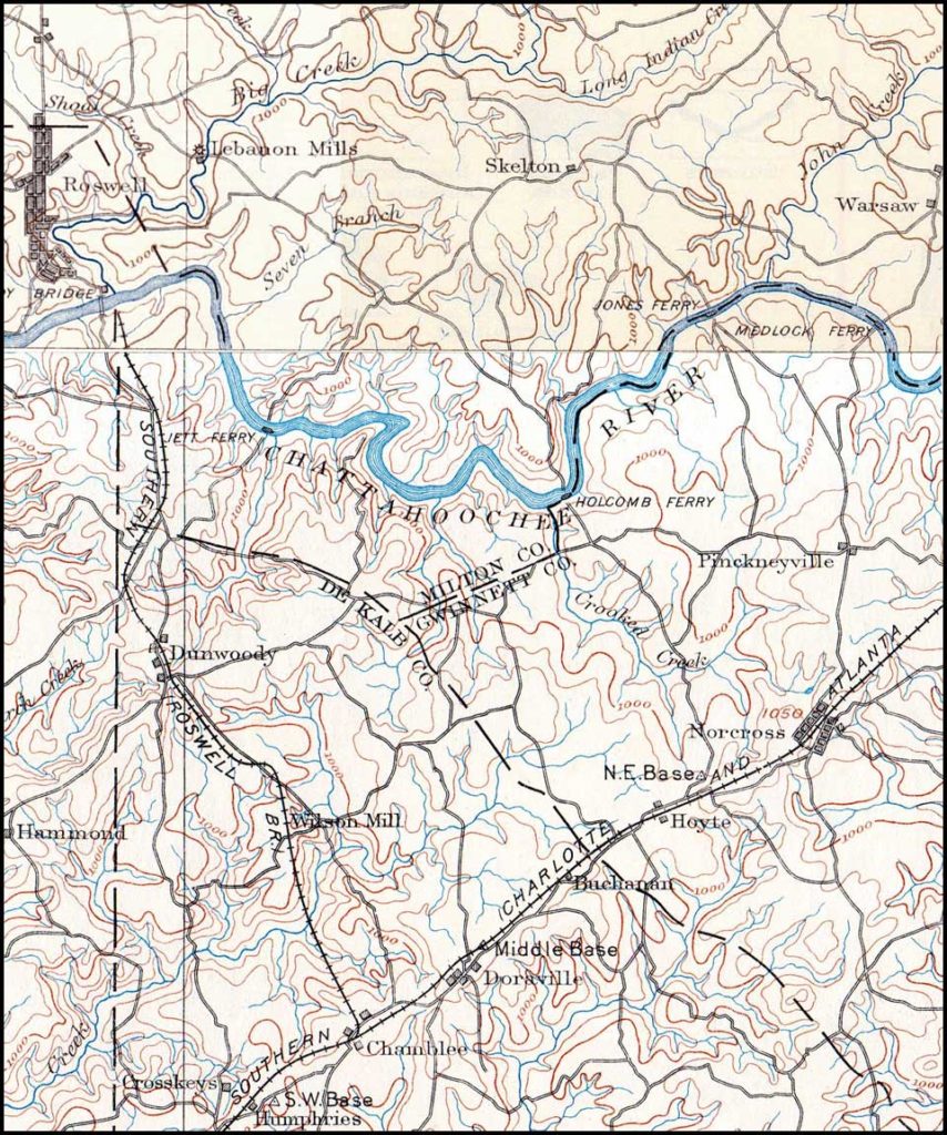
The railroad followed very roughly the present-day Chamblee-Dunwoody Road to the center of old-town Dunwoody, where the building located at 5518 Chamblee-Dunwoody Road was a section house.
The original Dunwoody depot was later moved and used as “Thompson’s Store”, but this building no longer remains.
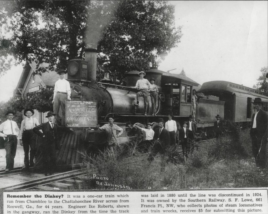
The line never actually reached Roswell, as the company was never able to build a bridge across the Chattahoochee. It ran along Roberts Drive and what is now Dunwoody Place, and ended near the present North River Tavern. This station was referred to as “Roswell” by the railroad. The engine house was “moved to by the river for use as a barn”.
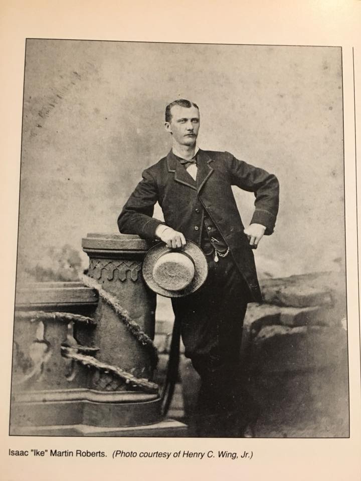
Roberts Drive is named after Isaac “Ike” Roberts, the “only engineer of the Roswell Railroad”, whose house still stands at 9725 Roberts Drive.
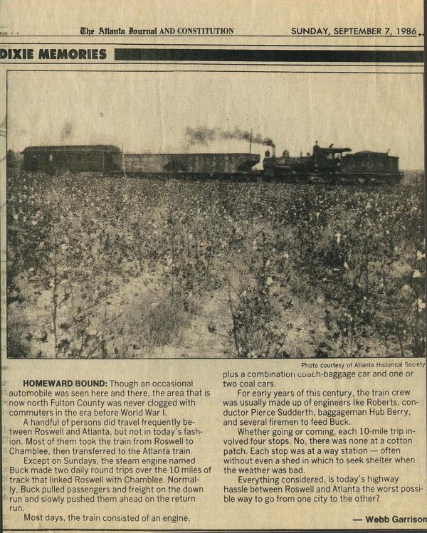
The final stop was Roswell Station, on the south bank of the Chattahoochee River, just east of the current Roswell Road. There was no means to turn the locomotive around, so it simply ran backwards on its return trip. The train was powered by 0-6-0-arranged Baldwin 1878 steam locomotive named “Buck.”
There was also a branch to the current location of Morgan Falls Dam.
The railroad famously was used by Teddy Roosevelt when he visited Bulloch Hall in 1905.
Theodore Roosevelt, who had begun his presidency on reasonably good terms for a half-northerner president, had infuriated the South by inviting Booker T. Washington to dine in the White House. Consequently, he waited a few years until the episode blew over and finally visited Bulloch Hall for the first time while touring the South in 1905. He was thought to be the first sitting President of the United States to visit the South since the end of the American Civil War, however this is incorrect as William McKinley had visited the South earlier while celebrating the victory of the Spanish–American War.
I have no recollection of Schambeau’s advertising on TV, especially not a spot this long. It looks like the early 80s. The kids shown buying from the candy counter were probably my classmates.
Schambeau’s was one of the two main grocery stores in Bayou La Batre, along with rival Greers. Schambeau’s was about a mile further from our house, but we shopped at both.
Schambeau’s was more of a General Store than Greers, which was purely a Supermarket. In the last years, Crum Schambeau was heard to remark that the real competition was the Walmart in Tillman’s Corner.
Schambeau’s did not long outlive Mr. Crum, due (I’m told) to his heirs not wishing to continue running the store. Greers continues.
When you grow up in Bayou La Batre, there are certain things long gone that you hear about from the older residents.
The railroad. The fine hotels destroyed by the 1906 and 1916 storms, never to return. The old bridge. (Twist: I remember that one, and the old Dauphin Island bridge too!)
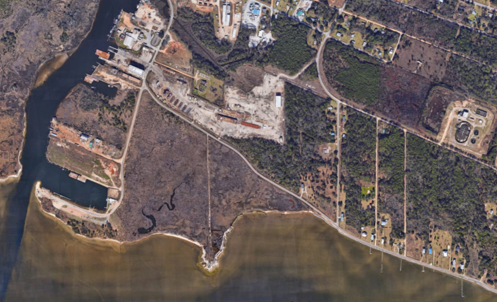
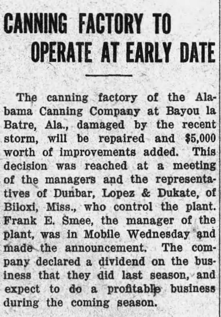
When we would drive around the shore on Shell Belt Road, my Pawpaw would point out a location where the “Old Factory” used to be. There was not even a trace of anything that looked like a building remaining.
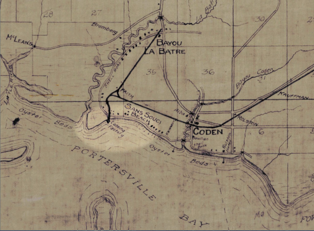
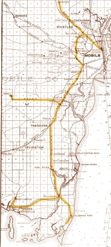
This map, dated 1918, shows a “Canning Factory” at the end of a railroad spur, located conveniently near to the “Oyster Beds”. I don’t remember anyone specifically saying that oysters were what was processed at the factory, but it would certainly make a lot of sense if it was.
The railroad here was the “Bay Shore” branch of the Mobile & Ohio Railroad, which operated from approximately 1899 to 1940. There is little to show of this line today, the rails having been physically removed soon after abandonment. It is memorialized by Railroad Street in the Bayou and Bay Shore Avenue in Mobile.
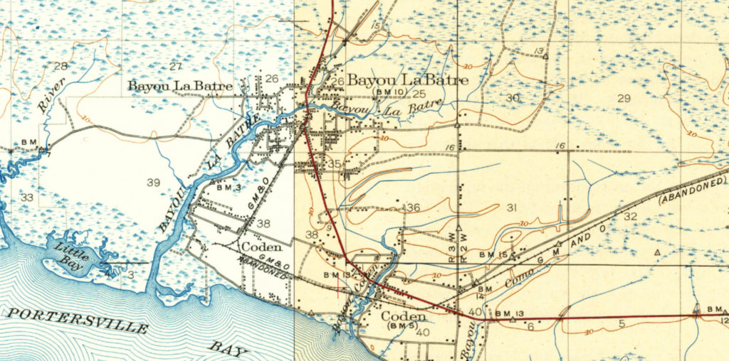
This (1926) map highlights the route from Mobile to Bayou La Batre:
At the far western end of the wye at San Souci was the lead to the Alabama Canning Company, also known as the American Canning Company. Alabama Canning Company was located on the north end of Coffee Island, about a mile south of the junction at San Souci. It was on this track that the trains would head down first, then back up through the wye toward Bayou la Batre.
The 1918 map disagrees about the factory being on Coffee Island, and I’m inclined to side with the map. An island location would have required the railroad to build a mile-long trestle over the bay. This does not fit with any description of this railroad that I’ve ever heard of before, and would have been a literal “bridge to nowhere”.
It seems more reasonable that the factory was located on the mainland.
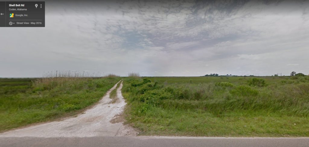
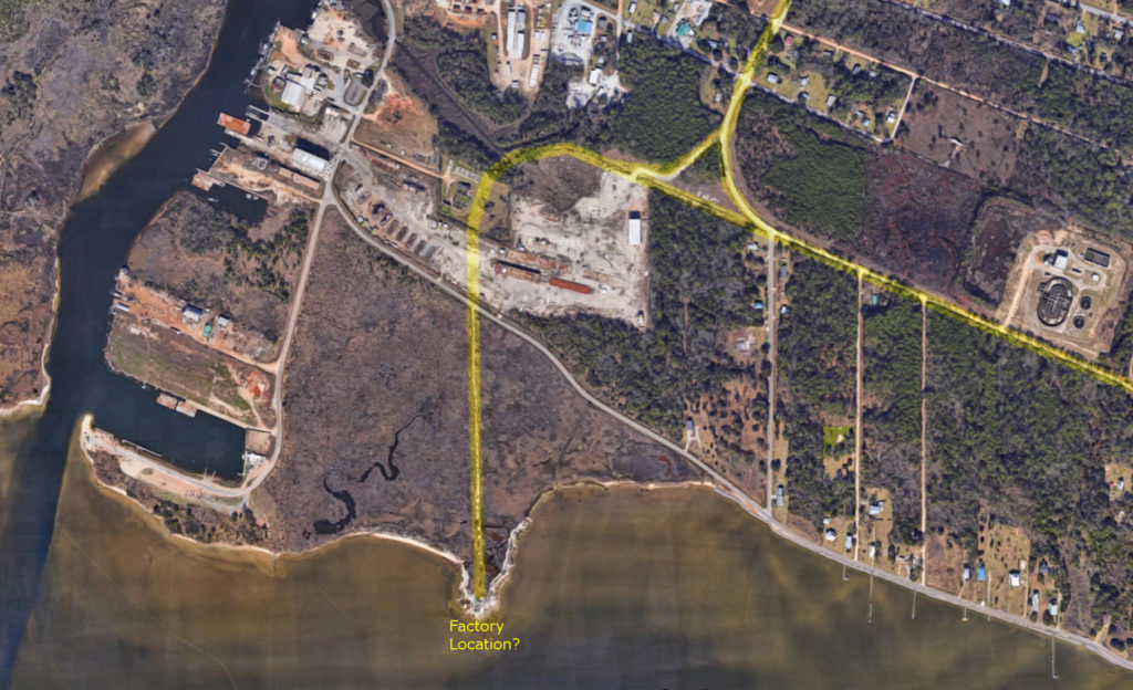
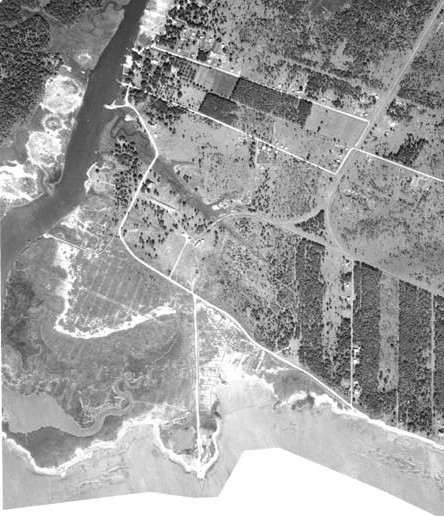
At the approximate location of where the “Old Factory” was said to be, there is still a dirt “road” off from Shell Belt Rd through the salt marsh, leading towards the shore of Portersville Bay. It goes to a point that naturally sticks out into the bay. It can clearly be seen on modern satellite images:
This is what it looks like in Google Street View (and in real life too!):
It is most consistent with the old map if this “road” is actually the railroad right-of-way. Here is the satellite image with the guessed route of the railroad tracks highlighted in yellow:
The real revelation happened when I began searching for more info on the “Alabama Canning Company”.
It turns out there are a lot of pictures of this place, located in the National Archives and the Library of Congress!
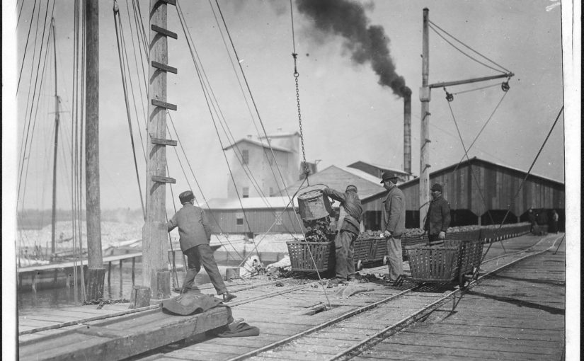
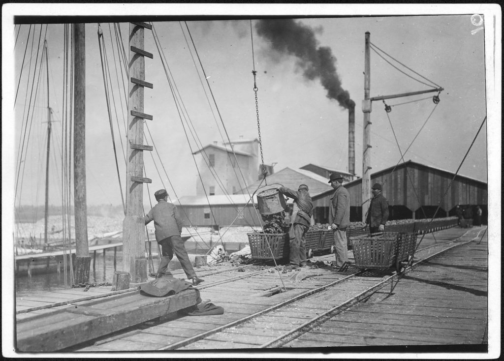
This photo shows oysters being unloaded onto the dock. It looks like they had a large pier running out into the bay, with railroad tracks utilized for wheeled oyster baskets. The factory in the background looks like a sizeable operation. It must have been the biggest industry in town at the time.
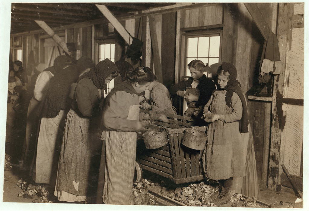
Many of the photos show very young workers in the factory and on the boats. This was the early 20th century, the era of child labor.
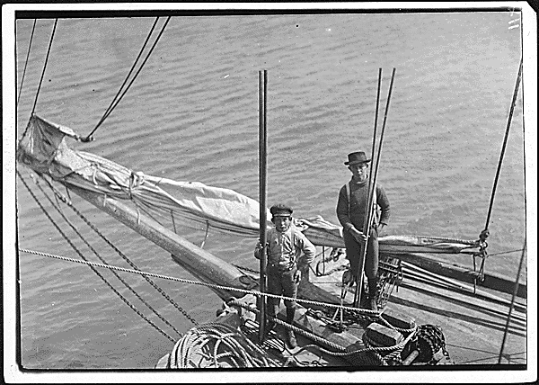
Original caption: “Alfred and Willie, two young oyster fishers in Mobile Bay. A few, but not many of these youngsters are found on the oyster boats. Bayou La Batre, Ala.” (National Archives)“Fred, a young oyster fisher; working on an oyster boat in Mobile Bay, the Reef, near Bayou La Batre, said he was fourteen, but not likely. ” (Library of Congress)“Shucking oysters in the Alabama Canning Company (Dunbar Lopez, Dukate Co.) Small boy on left end is Mike Murphy, ten years old, and from Baltimore” (LOC)“On right-hand end is Marie —, eight years old, who shucks 6 or 7 pots of oysters a day (30 or 35 cents) at a canning company. At left end of photo is Johnnie —, eight years old, who earns 45 cents a day. Been shucking for three years. ” (LOC)
“Little Nettie [?], a regular oyster-shucker in Alabama Canning Co. She speaks no English. Note the condition of her shoes, caused by standing on the rough shells so much, a common sight”. (Other versions identify the subject as “Lottie”)These photos were taken about 1912-1913. The children would have been born in the first decade of the 20th century. This is about the age of my great-grandparents. If you are from Bayou La Batre, some of them could be your great-grandparents, if not great-great-grandparents.
The work was seasonal, with many families coming to town only during the cooler months when oysters were in season. You can see in the photos almost everyone is dressed for cooler weather. Many of the workers were also immigrants, as the captions mention some children being unable to speak English. From the Mississippi Gulf Coast Museum of Museum of Historical Photography website:
The [labor shortage] problem was resolved initially by bringing in Eastern European immigrants known as ‘Bohemians’ from the Baltimore, Maryland canneries. The Baltimore people traveled in special railroad cars from their homes in Baltimore to work the canneries during the winter oyster season along the coast. They lived in factory-owned camps near the canneries, and the children rarely attended local schools. Some of the Baltimore families stayed on after the oyster season.
We can assume the hiring practices established in Biloxi were also followed in Bayou La Batre.
It turns out the reason all of these 100-year old pictures from Bayou La Batre are part of the national historical record, is because they were part of a famous series taken by Lewis Wickes Hine. Lewis Hine is an unsung hero of American labor relations, risking his own safety to end the practice of child labor in this country.
Lewis W. Hine
In 1908 Hine became the photographer for the National Child Labor Committee (NCLC), leaving his teaching position. Over the next decade, Hine documented child labor, with focus on the use of child labor in the Carolina Piedmont,[3] to aid the NCLC’s lobbying efforts to end the practice.[4] In 1913, he documented child laborers among cotton mill workers with a series of Francis Galton‘s composite portraits.
Hine’s work for the NCLC was often dangerous. As a photographer, he was frequently threatened with violence or even death by factory police and foremen. At the time, the immorality of child labor was meant to be hidden from the public. Photography was not only prohibited but also posed a serious threat to the industry. To gain entry to the mills, mines and factories, Hine was forced to assume many guises. At times he was a fire inspector, postcard vendor, bible salesman, or even an industrial photographer making a record of factory machinery.[5]
So here we have a connection to historical events of national importance, right there in Bayou La Batre, and all that’s left of it is a dirt path through the marsh grass and scattered recollections of an “Old Factory”.
Hine is also the photographer of a very well known series on the construction of the Empire State Building.
So when was this factory built, and whatever happened to it? The Bay Shore website says:
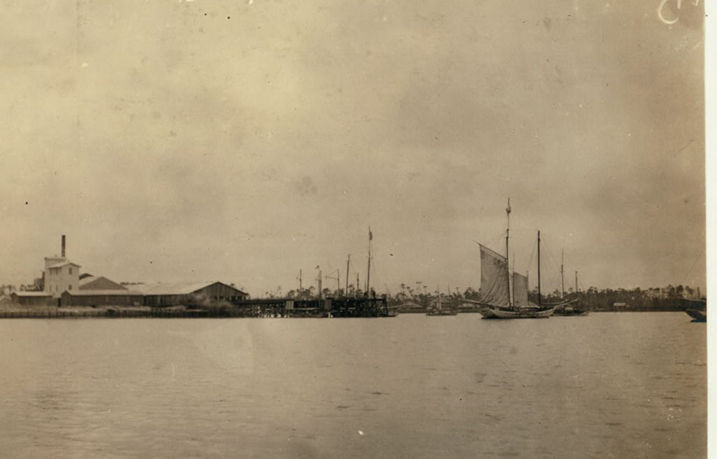
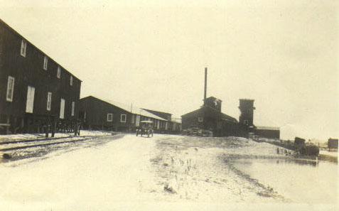
Below is a photograph taken before the hurricane of 1906, showing the company tracks on the west side of the building. The photographer is facing south, toward Portersville Bay.
The buildings seen in this image were either heavily damaged, or destroyed, in the 1906 hurricane, and the company either elected not to rebuild, or was financially unable to. At a later date (unknown) this location became the Dunbar & Ducate Factory. Dunbar & Ducate was later destroyed by a boiler explosion which claimed the lives of several employees.
“Dunbar & Ducate”, (or DuKate) had already taken over by the time of Hines’ photos in 1912-1913 (and indeed some of his captions refer to it as such).
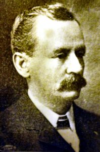
W.K.M. DuKate
The Biloxi Historical Society lists a number factories owned by several firms involving the DuKate family, including “Dunbars, Lopez, & Dukate Company“, in Alabama, Mississippi, and Louisiana. It appears that it was often called the “Alabama Canning Company” even when it was owned by DuKate.
Julian Lee Rayford, writing in 1956, describes a world already long gone, including a “Big Factory” owned by “Dunn, Barr, and Ducate”.
GEORGE BRYANT told me about the factories
in Bayou la Batre.
The factories fall into two classes. First, the
factories of 1915, and a few years later. And,
second, the factories of today. There is little con-
nection between the two. True, the factories have
always canned shrimp and oysters, but there is a
distinct contrast between the periods.
Pure Food Laws have cleaned them up, and
now, everything is peaceful and quiet in the fac-
tories. Government inspectors stand on constant vi-
gil making the pickers maintain purity and quality
in the products.
After 1906, the factories lined the Bayou.
There was the Union factory, operated by the
Union. There was the finest and largest, the one
run by Daughdrille. On the coast, was the “Big Factory,” controlled by Dun, Barr and Ducate. And
there was the “Green Factory,” so called because of
the color used on the outside of the building. All
along the Bayou were the picking sheds, which sent
their products to the larger establishments to be
packed, or, canned.
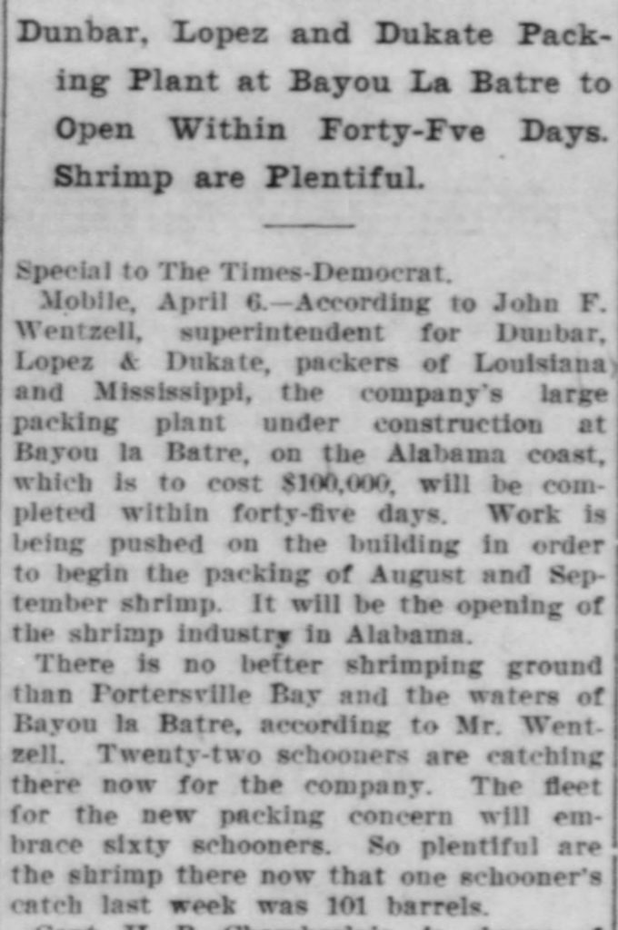
An article in the New Orleans Times-Democrat, April 7 1910, mentions a factory being constructed by this company in Bayou La Batre:
The John F. Wentzell mentioned here is probably related to Wintzell’s Oyster House founder J. Oliver Wintzell, as well as the Wintzell family of Bayou La Batre.
The factory is described as packing shrimp. It is not clear if this was the same facility as the oyster plant shown in the photos, or a different plant also located in Bayou La Batre.
I cannot find any information about the existence of the Alabama Canning Company earlier than this. It is possible it operated under a different name before DuKate took it over, if it actually existed before 1910.
The plant survived and was repaired after the 1916 storm:
I can only find one other page about an explosion, the Find-A-Grave page for Robert Walter Cox who died on August 16, 1923 when an ammonia tank exploded in the ice plant of the cannery. It reads like a newspaper article, but there’s no citation and I cannot find the same story anywhere else.
EXPLOSION KILLS ONE AND INJURES TWO AT ICE PLANT
Ammonia Tank Blows Up At Bayou La Batre, Killing Robert Cox and Wrecking Plant
Death injury and heavy property damage resulted form a violent explosion at the ice pant of the Alabama Canning Company at Bayou la Batre Thursday night. Robert Cox, 40 years old, frieman at the plant was almost instantly killed and two other persons, Willie and Aime Castello, father and son, recieved serious injuries. The disaster occurred when an ammonia generator exploded, wrecking the one-story structure. The loud noise which accompanied the explosion attracted the attention of people throughout the community, many of whom hurried to the scene.
Cox was discovered in a dying condition outside the boiler room a few minutes after the generator exploded. The younger Castello was huried to the roof of the building from which he was rescued by persons who rushed to the plant. Willie Castello, the father, is an engineer at the plant according to information received in Mobile. His son is tankman at the ice plant.
Shortly after the accident a Mobile physicain was summoned to treat the injured. The small casualty list was apprently attributable to the fact that only a few employees were on duty whe the explosion occurred.
Perhaps this explosion was too much for the Big Factory to come back from, and put them out of business. Perhaps the Pure Food and Child Labor laws had made the business unprofitable. Or maybe decreasing supply due to overfishing. Or a combination of all these things.
By the time of this 1943 map, the railroad is abandoned, the spur track for the factory is already just a dirt road, and the there is no indication building where the factory would have been.
When I was a kid in the early 1980s, the public library had a children’s movie program once a week during the summer. My mom, and I think most of the other parents who took advantage of it, would drop us off at the library and go do her shopping or whatever other errands she needed to run, while we sat in a darkened wing of the library and watched movies.
I’m guessing they were legally only allowed to show things that were in the public domain. Because everything they showed was old. Some of it as old as the 1920s.
Sometimes they would show silent movies and cartoons, which was a problem because the audience included children too young to read. The older children were expected to read it out loud for the younger ones.
Many of the cartoons I saw there, I later learned were so old that they were significant in the development of animation!
Things I can remember seeing there:
Lotte Reiniger’sCinderella – 1922 silent, black and white “cartoon” where all the characters are just black silhouettes. You can imagine how this confused the hell out of a bunch of 80s kids.
Max and Dave Fleischer’sGulliver’s Travels – 1939 technicolor feature film, the first such released by a non-Disney studio. The high budgets of this and their only other feature, Mr. Bug Goes to Town, contributed to the Fleischer studio losing its independence and becoming part of Paramount.
Lev Atomanov’s The Snow Queen– 1957 animated feature from the USSR. The fact that this got an American dub release in 1959, with an all-star cast, seems like it must have been a triumph of Cold War diplomacy.
Some weird, silent (but color?!) thing with puppets.
Question to my librarian friends, do ya’ll still do stuff like this?
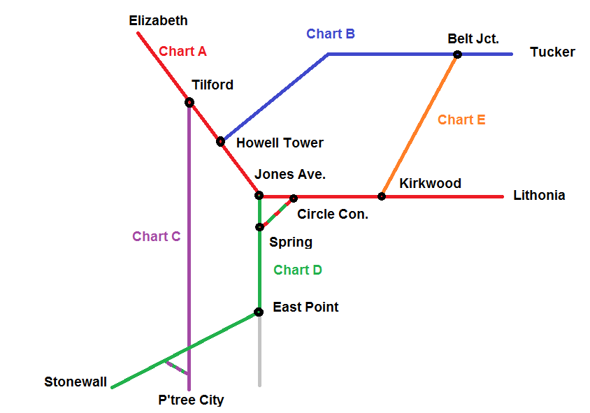
Here I reproduce information from the Norfolk Southern and CSX timetables. I have many times wished I had this to pull up on my iphone in a form other than the bulky PDFs this data is from.
Stations marked “not in timetable” represent signals that trains have been observed to call out (“Clear Doraville, NS 203 southbound”) over the scanner. NS generally does not list intermediate signals (between control points) in their timetables, but they may be shown on their track diagrams. Not sure about CSX.
Text in italics is additional commentary, not from timetable.
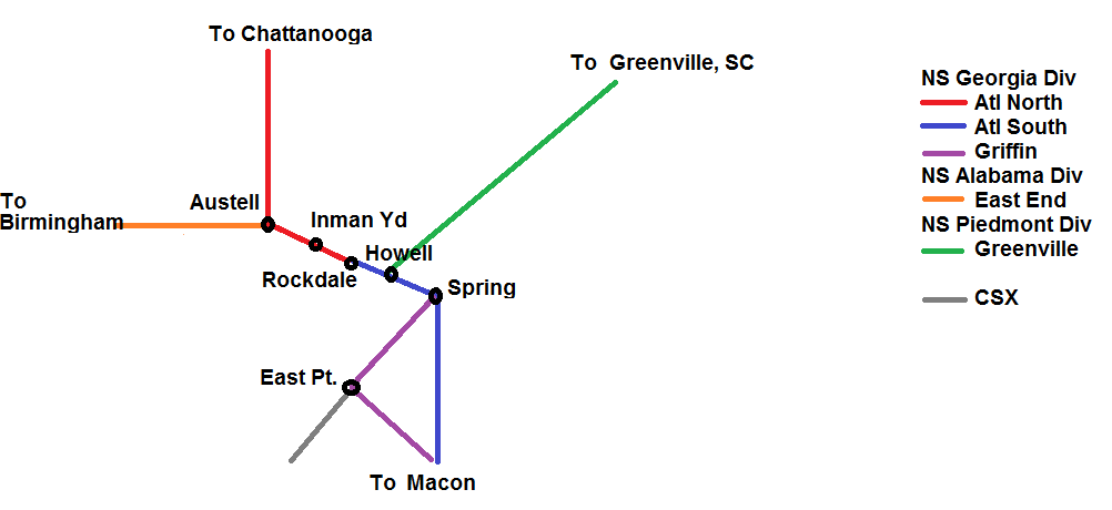
Norfolk Southern
First, a “British subway map” of these lines. Obviously not to scale.
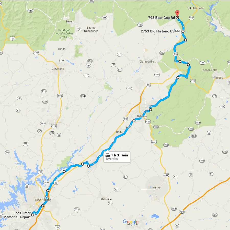
Picking up where the last one left off, this gets you out of the burbs and into the woods. At the northern end, it gets you into the mountains, even.
The route through Gainesville is rather arbitrary and I’m not sure how close it follows the divide.
You are pretty much running parallel to US 23 (when you are not actually on US 23) all the way.
The early parts of this route are very close to Lake Lanier.
From Lula through Mt. Airy, you are running directly beside the Norfolk Southern main line.
I have only been as far north on this route as Alto, so I can’t really say what the remainder of it looks like.
The end point here looks to be about as far as you can follow the ECD on public roads. From here, the ECD turns westward and generally forms the Habersham/Rabun county border until meeting the Tennessee Valley Divide at Young Lick. I don’t see any roads that directly follow this ridge, not even dirt Forest Service roads. From Young Lick, the ECD continues north on the Appalachian Trail. At that point, following the divide becomes more of a matter of hiking than driving.
Start on Aviation Blvd, continue east from last time
Right on GA 60
Left on West Ridge Rd
Right on Athens St
Left on East Ridge Rd
Left on Old Cornelia Highway
Right on US 129
Left on White Sulphur Rd
Left to stay on White Sulphur Rd
Left on Cagle Rd
Right on GA 52
Sharp left on GA 51
Continue onto Main Street (Lula)
Continue onto Gainsville Highway
Continue onto Old Cornelia Highway
Continue onto Willingham Ave
Continue onto Main Street (Cornelia)
Right on Highland Ave
Left to stay on Highland Ave
Continue on Chenocetha Dr
Right on Wyly St
Continue on Dicks Hill Pkwy
Left on Rock Rd
Left on Antioch Church Rd
Right on US 23/US 441
Right on John Wood Rd
Left on Tom Born Rd
Right on Old Historic US 441
Left on The Orchard Rd
Right on Bear Gap Rd
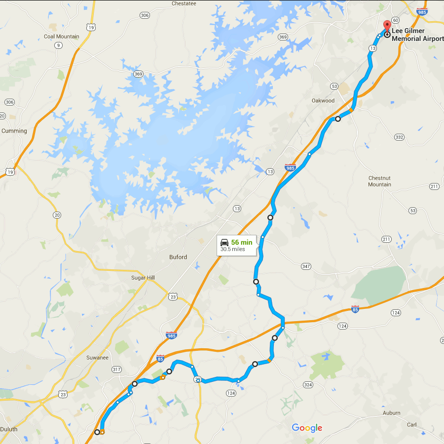
Picking up where the previous route through Atlanta ended, this follows the ECD (within the limits of road placement) through the northeastern metro area. To be honest this is a rather boring drive through the suburbs. You can skip to the next post to pick it up where things get mildly interesting again.
The earlier part has some shenanigans with Old Peachtree Road, leaving it without turning and turning to stay on it at different points.
The segment on GA 20 is an area where no road follows the ECD. If you look close at a topo map you’ll see this section crosses a creek, not something you’ll see when following a ridge line.
The segment on GA 124 passes the site of Ft. Daniel, one of the original endpoints of the trail that became Peachtree Road.
The GA 13 portion mostly runs closely parallel to I-985.
Gainesville’s airport is an arbitrary stopping point dictated mainly by limitations on the number of route modifications that Google Maps allows you to make.
(Aside: notice how close the divide is to Lake Lanier? The western edge of Lake Lanier’s drainage basin is also visible on this map, over near GA highway 9. The lake is really not very far at all from the boundaries of the area drained by it.)
Start at Old Peachtree Rd and I-985, go east
Left on Northbrook Pkwy
Continue on Old Peachtree Rd
Continue on Horizon Dr
Left on Old Peachtree Rd (yes, again)
Left on Rock Springs Rd
Right on GA 20
Left on Old Peachtree Rd
Left on GA 124/Braselton Hwy
Left on Hamilton Mill Rd
Right on Ridge Rd
Continue onto Hog Moutain Rd
Right on GA 13
Right on Industrial Blvd
Right on Aviation Blvd
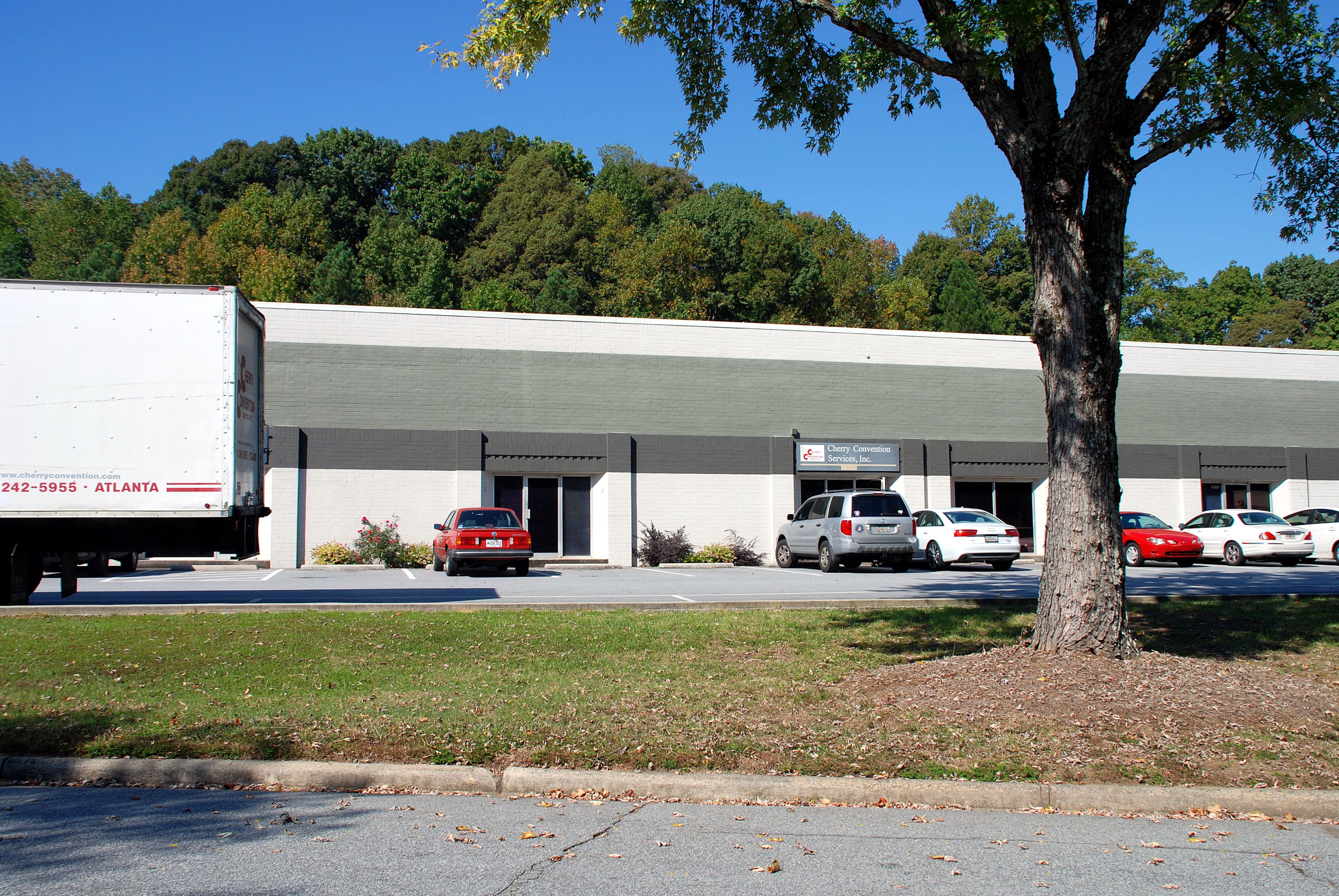
Studio One was a recording studio, located in the northern Atlanta, Georgia suburb of Doraville. The address was 3864 Oakcliff Industrial Court, Doraville Ga 30340. It is now occupied by a non related business and used as a warehouse.
Check out the list of albums recorded here, it includes not only four Lynyrd Skynyrd album but also probably the earliest recording featuring Ronnie James Dio on vocals.
In the 1970s and 1980s Doraville was a haven for blue-collar white Southerners, aka rednecks. This was gone by the early 2000s, as much of the original population was displaced by immigrants.
This is what the address on the wiki page looks like today. I almost have a hard time believing it. The red car in the center of the picture is parked next to the door of number 3864.
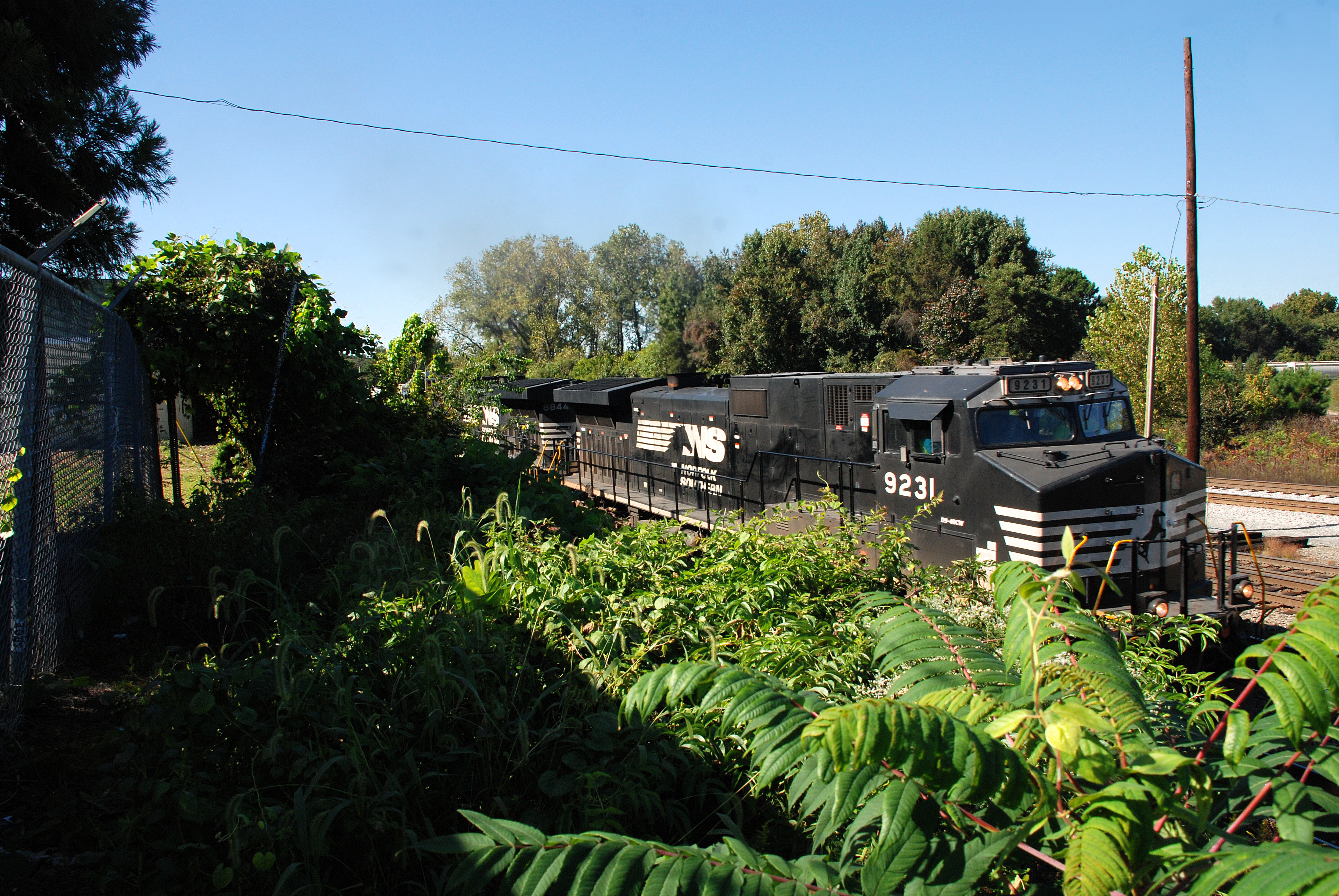
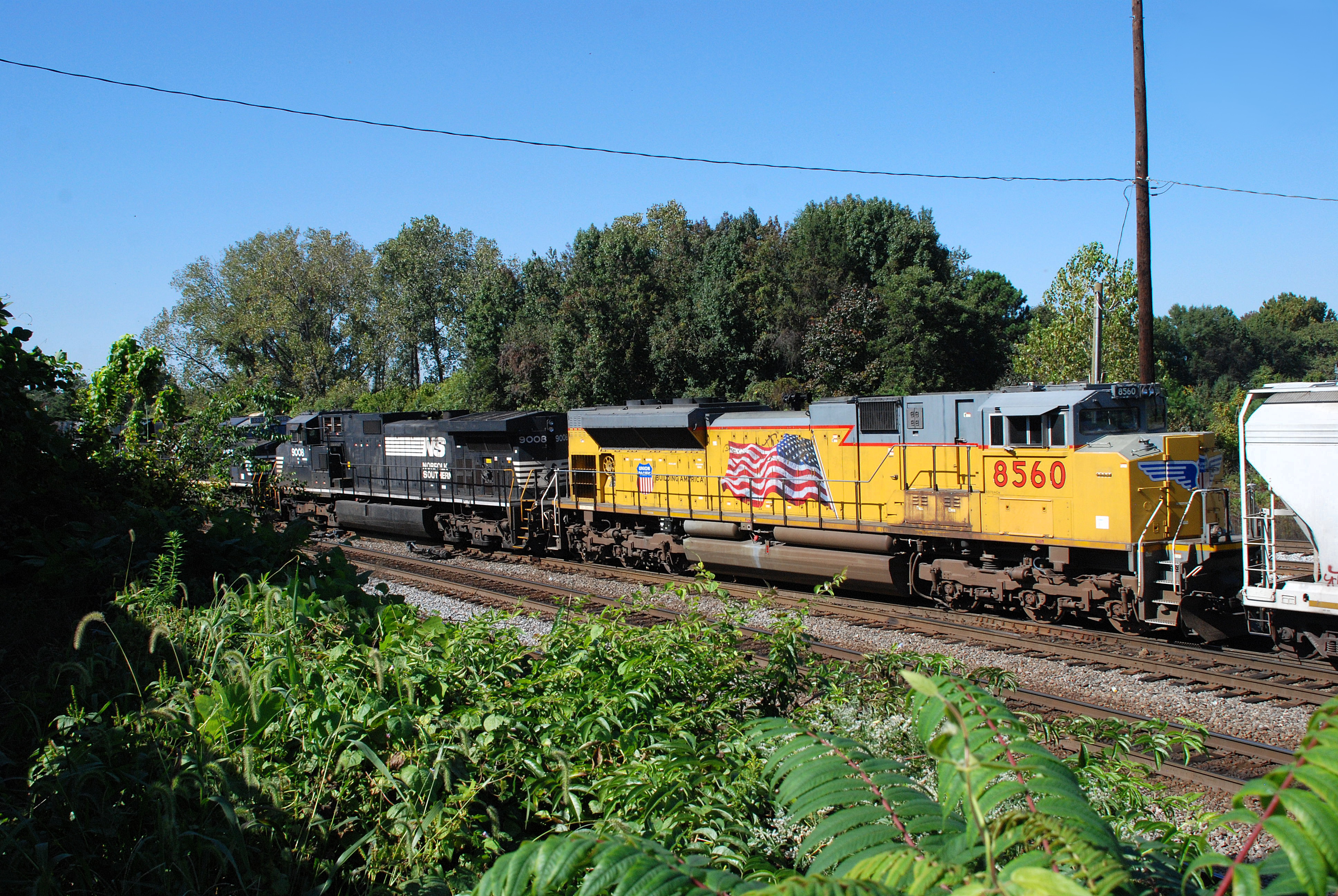
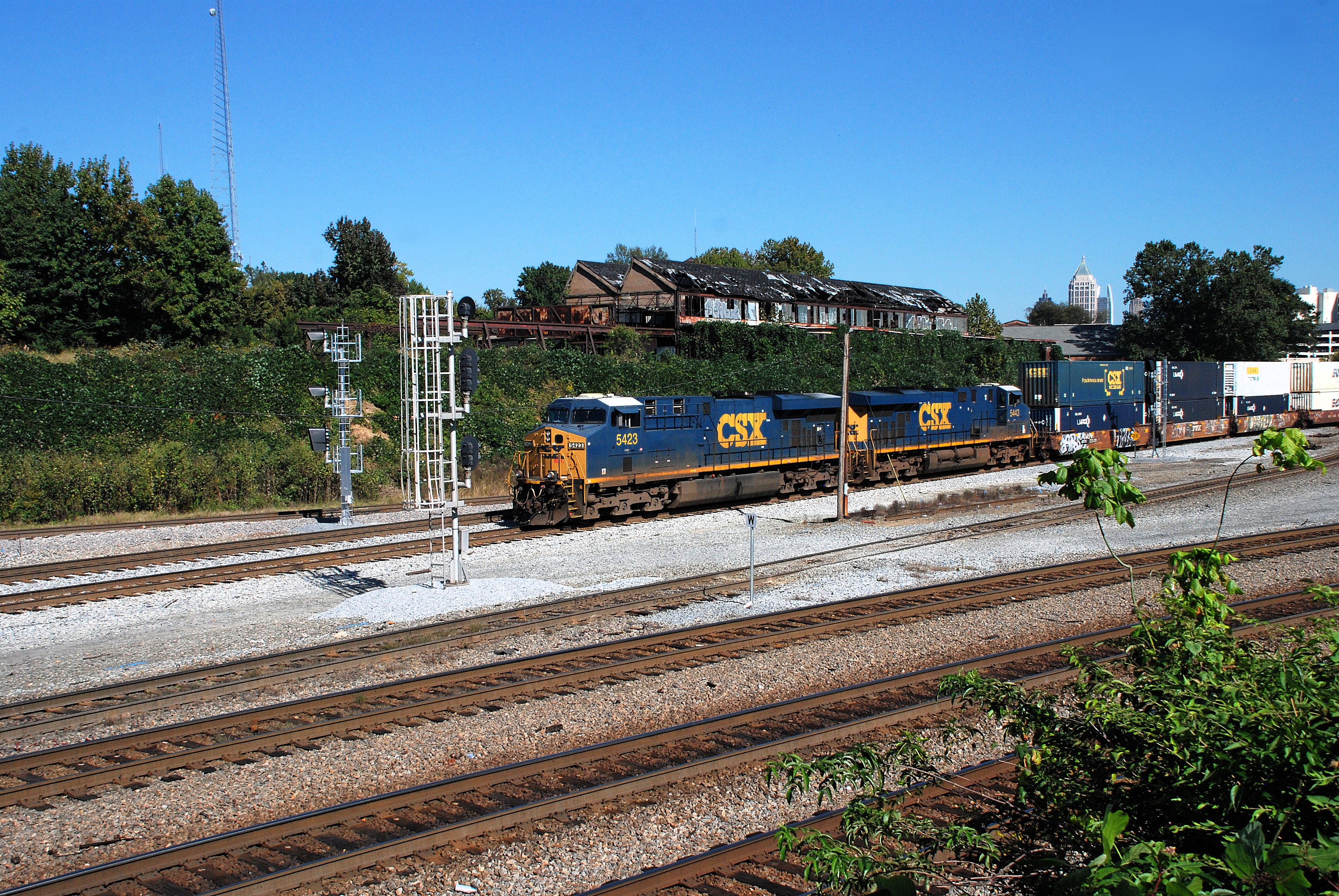
One of the constant elements of southeastern railfanning is kudzu, sumac, honeysuckle, wisteria – you know, weeds. As summer turns to fall, we have one last chance to appreciate all that luscious green foliage.
Trains sneak out of the underbrush like wild animals.
In a few months this will all be gray and brown.
By the way, Pokeweed was traditionally used as a source of food in the South and in Appalachia even though it is toxic. I guess our ancestors would rather risk being poisoned by their food than not having any at all.
Sumac, visible in most of these shots, has some species that are used as flavorings (such as for tea), but I wouldn’t try it with this wild stuff.
Edit: this is probably Rhus glabra, smooth sumac. It is supposed to be edible, although it is not the same species cultivated for tea.
Kudzu leaves are edible as well but in the South you never know that the kudzu you pick wasn’t sprayed with something nasty in an unsuccessful attempt to kill it.
All these plants attract bees and wasps, which were buzzing around during these shots, although it was kind of hard to hear them over the trains.
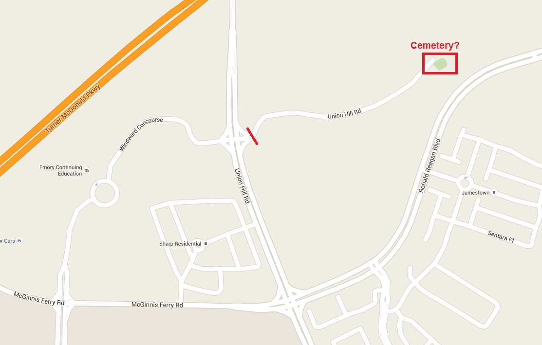
Sometimes I use Ronald Reagan Blvd as an alternate to GA 400 between exits 11 and 12. This road goes through mostly vaporware developments – planned subdivisions, some of which don’t seem to have even started construction, others seem to have had some grading and nothing else. Lots of places where they put it in a turn off of the main road but it just dead-ends into a field. That sort of thing. This is literally where the streets have no name.
Recently I noticed, off to the west side of the road, what appeared to be a graveyard on a hill overlooking a construction zone. I decided to try to find it.
Now, on the map, it looks like you can get there via Union Hill Road:
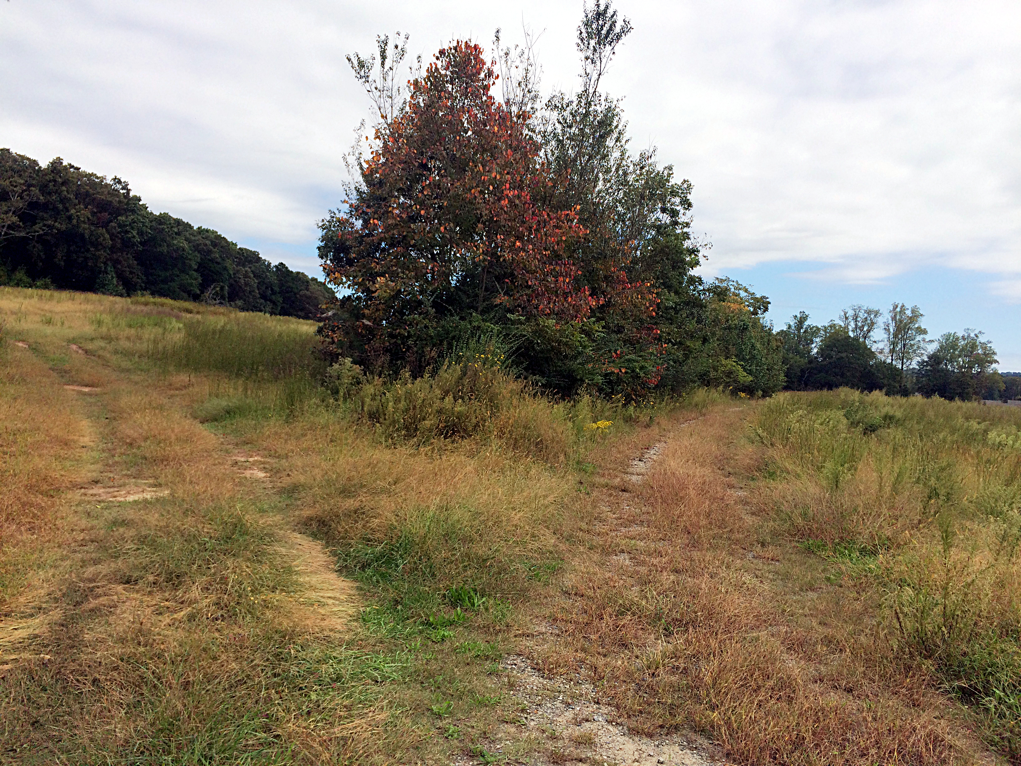
But, where I drew that red line across the road, that’s where you find this gate:
So, clearly I’m not driving there. It was a nice day for a walk, though. You can of see some traces (as in the next photo, on the right path) that this road was once paved, but the pavement is very much going back to nature. Maybe it will someday again be paved. I hope not.
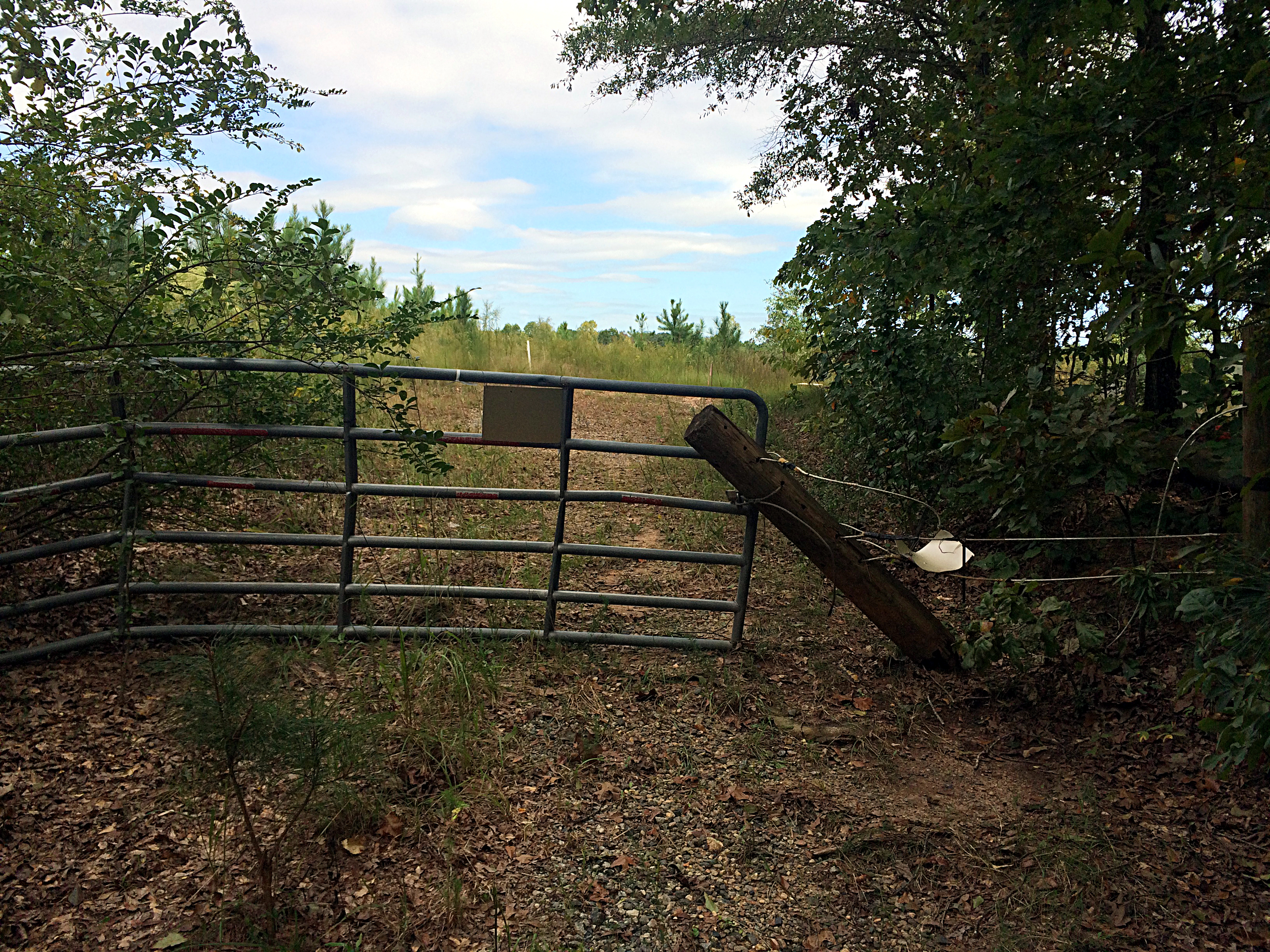
At the end of the road is another gate. This one has a “no trespassing” sign but the sign is facing the other way from where I came. I don’t know who they are trying to keep out from that direction.
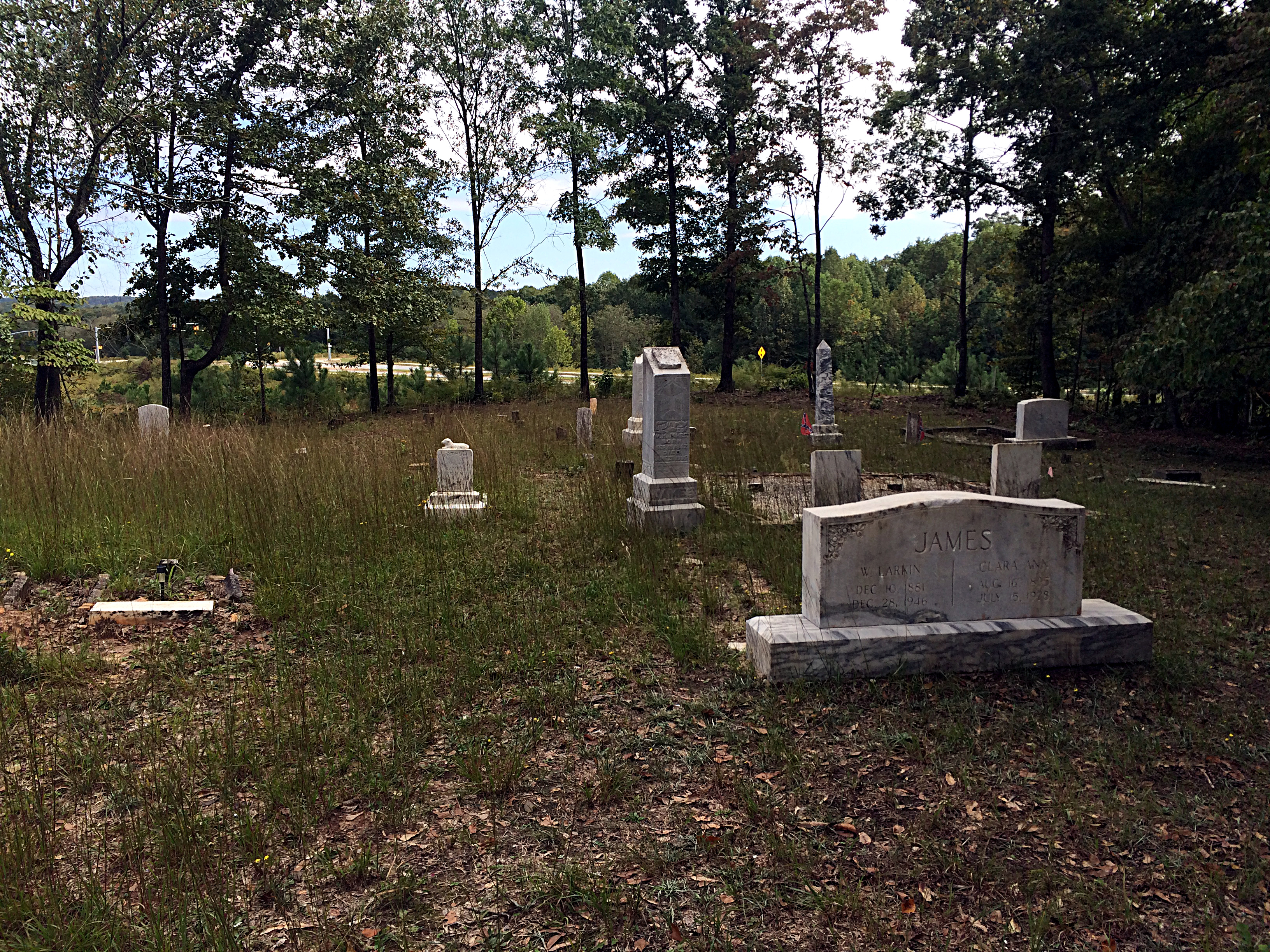
Beyond the gate is the cemetery:
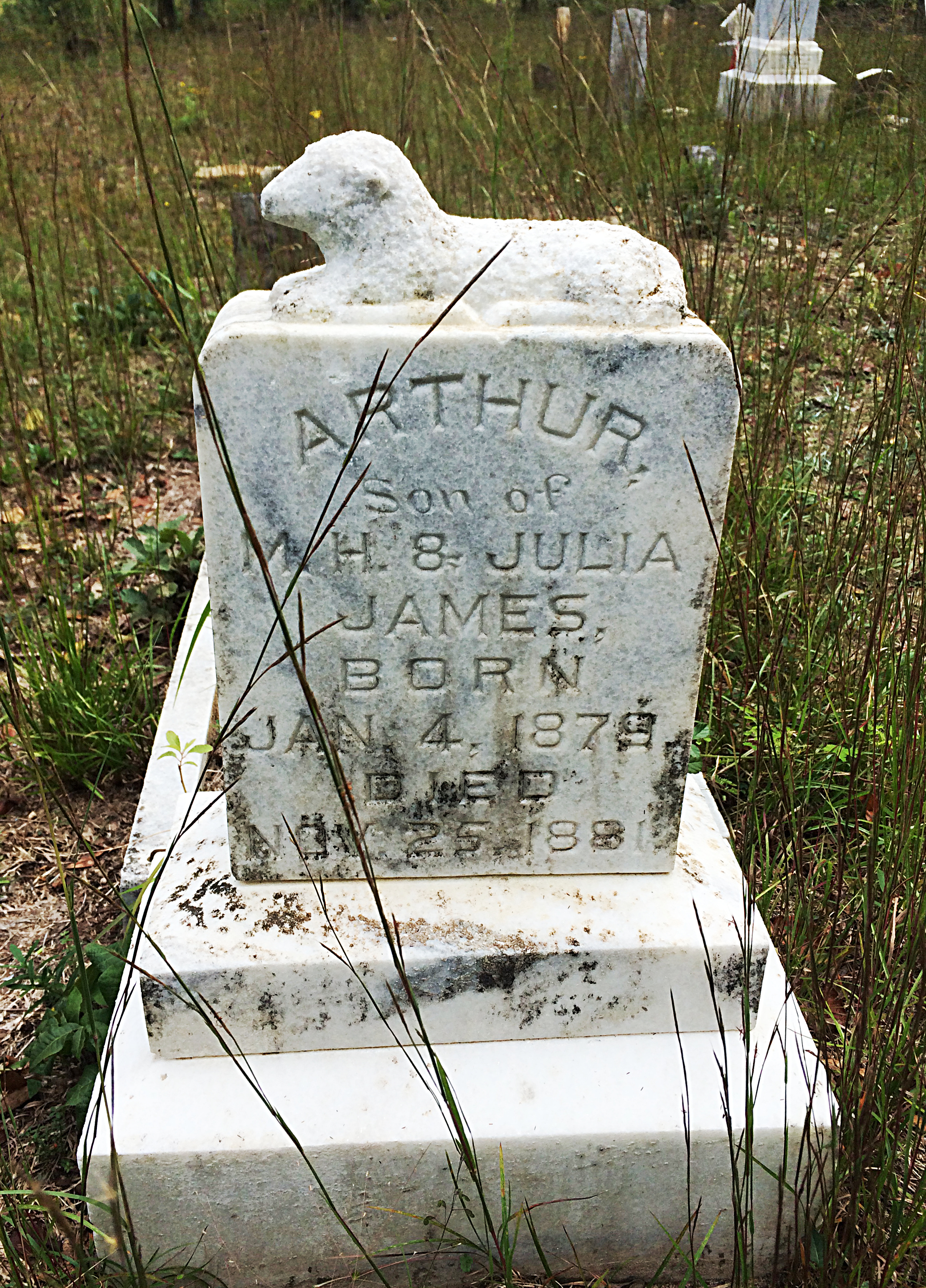
Most of the graves seem to belong to a James family, and on the topographical USGS map this is in fact marked as “James Cem”. The most recent date I saw was 1978, but they are mostly 19th century dates. Confederate flags are planted next to several that are Civil War era.
This graveyard clearly is still maintained, someone cuts the grass here and those flags look pretty new.
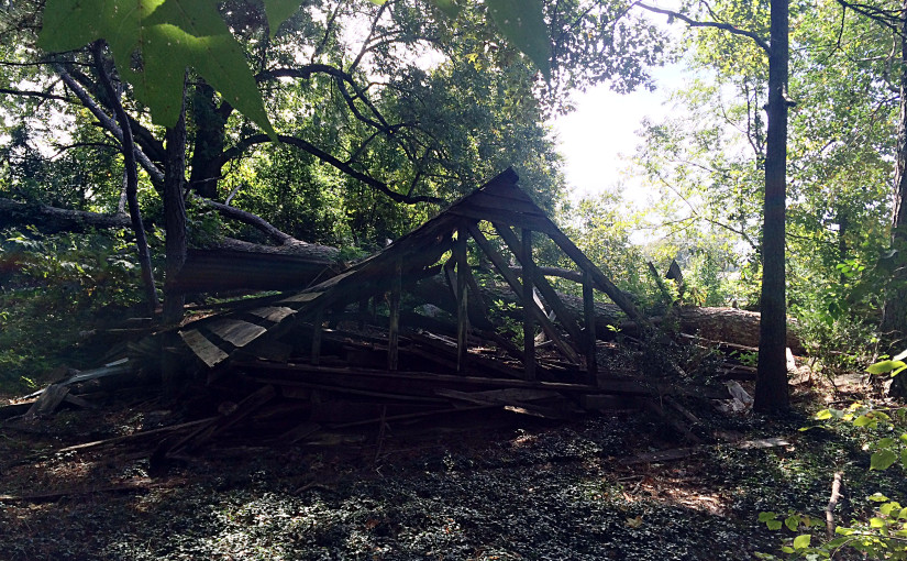
After this, I decided as a bonus to explore some nearby old houses back on the road.
This is all that’s visible from the street, and really gives no clue:
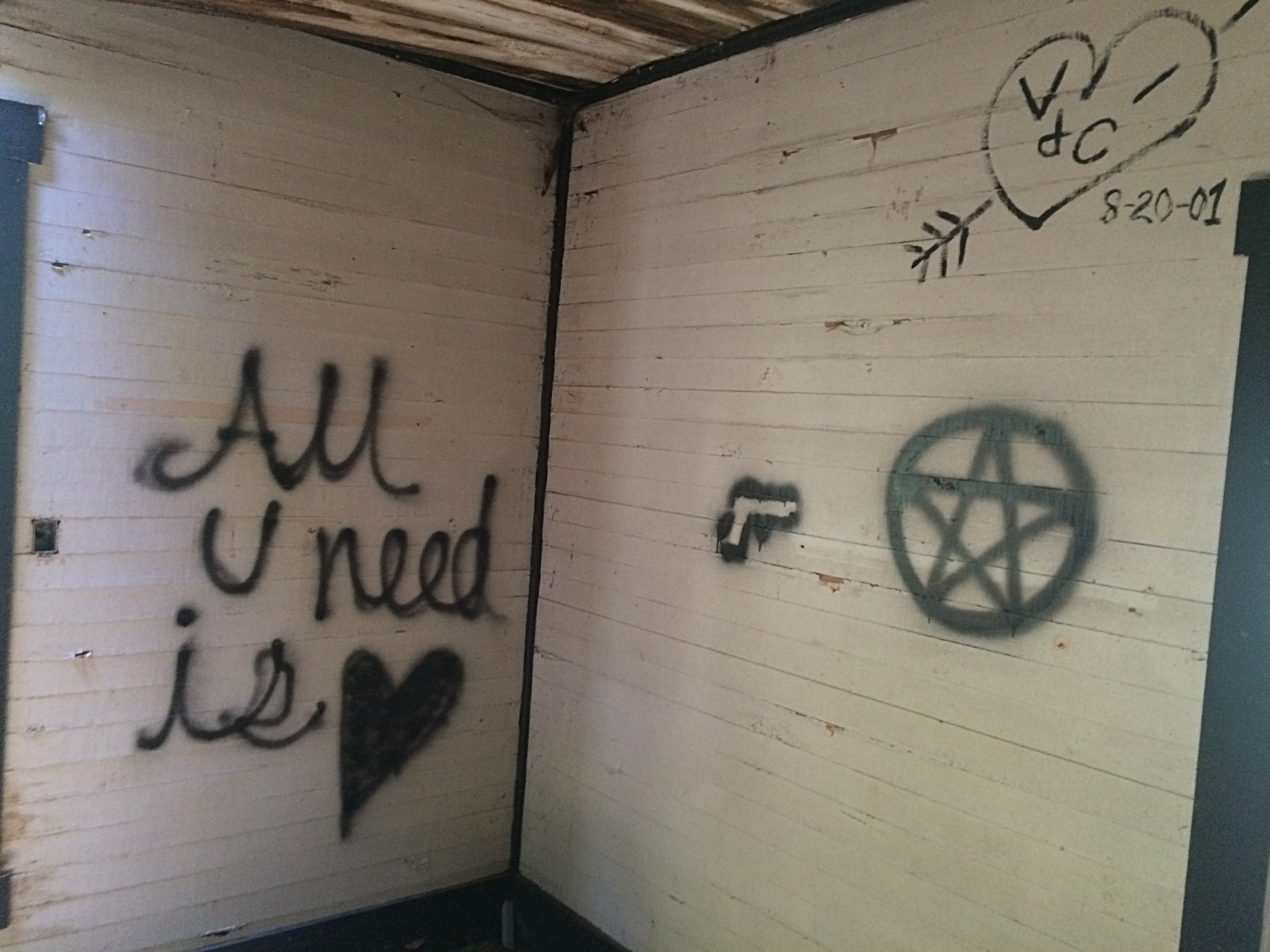
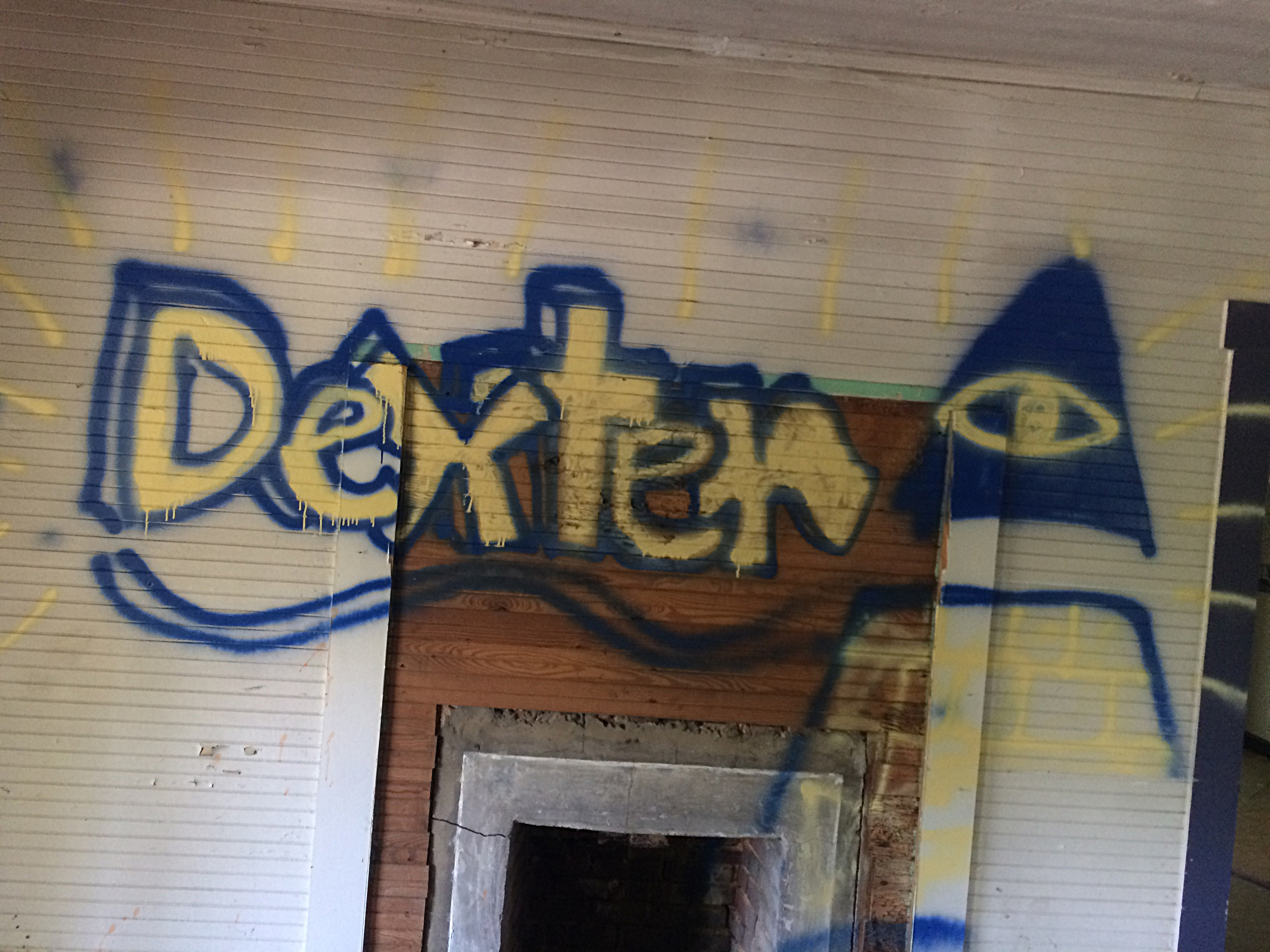
The inside of this building has some graffiti, but even that is dated from 2001!
Dig this chair!
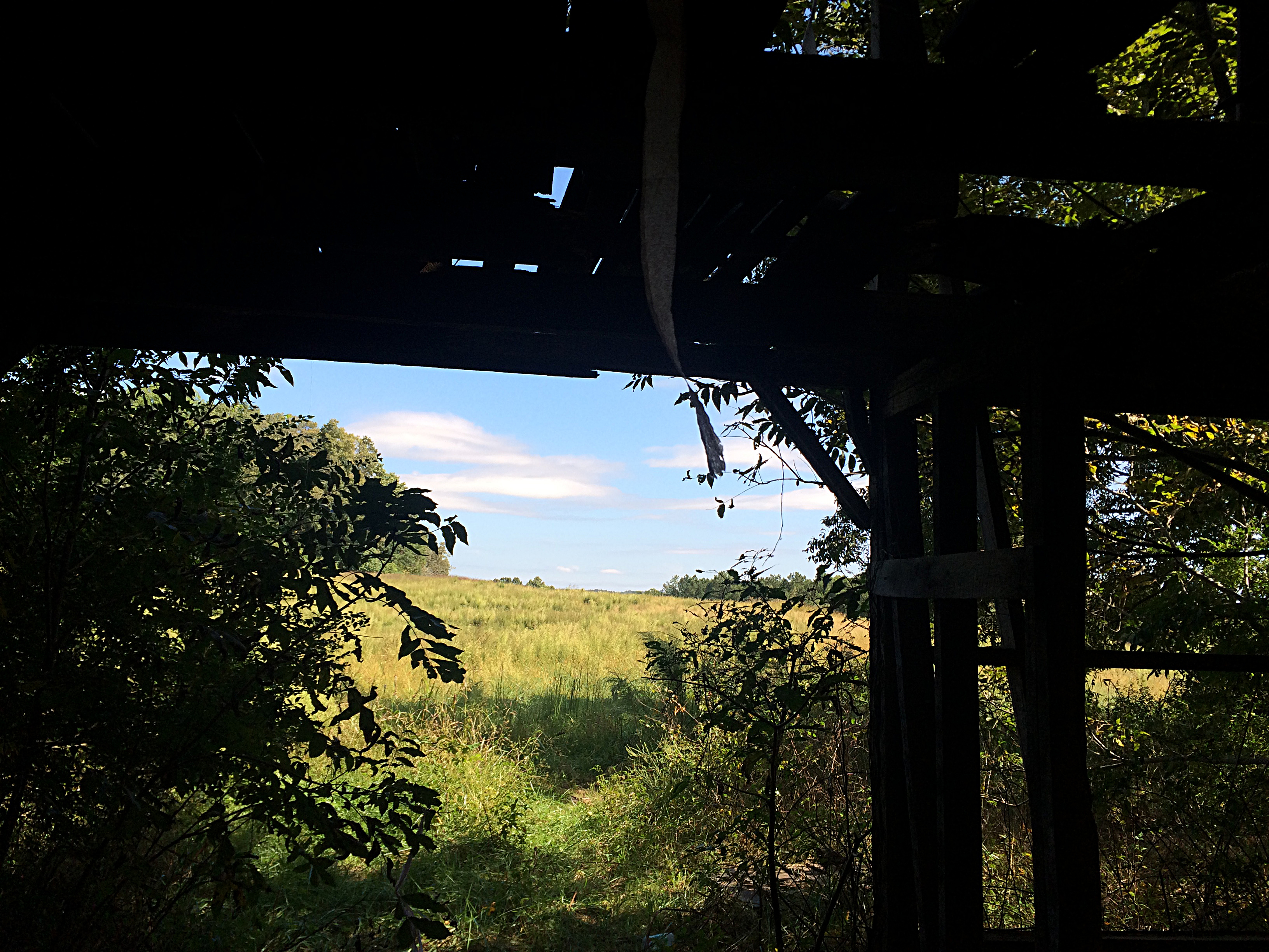
The adjacent buildings here are nothing but frame. Only a little bit of siding remains, someone has removed the rest of it.
Now all the remains is the “bones”, facing out over the empty field.
All those new neighborhoods being built nearby, some of those people in those houses must have kids. I hope those kids run around unsupervised in these fields and these woods and ruins, trespassing and risking injury. One can dream.
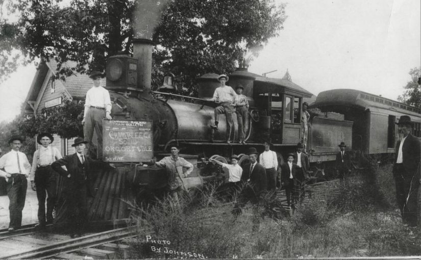

The final stop was Roswell Station, on the south bank of the Chattahoochee River, just east of the current Roswell Road. There was no means to turn the locomotive around, so it simply ran backwards on its return trip. The train was powered by 0-6-0-arranged Baldwin 1878 steam locomotive named “Buck.”


