Some parts of the US have a variety of roads that, while technically maintained as public road by some combination of county, state, US forest service, bureau of land management, etc., have more of the character of offroad “trails” than what most people think of as a “road”. Many offroading videos available on youtube feature “trail riding” activities on what are actually just really lackadaisically maintained roads. (this is actually not a good thing, as explained below)
Illinois is emphatically not one of those states! Most of the roads, even backroads far from any city, are as level as a tabletop, straight as an arrow, and often paved. If not with regular blacktop asphalt, then at least with chipseal. Especially in the counties that have cities in them, even the very rural areas tend to have paved roads.
(I was not familiar with chipseal until I moved here. In the south, I think, any road that Illinois would chipseal is just left as plain gravel, aka what we called a “dirt road”.)
There are exceptions. The counties known collectively as Forgottonia, which are mainly the far western counties cut off from the rest of the state by the Illinois river, have lot more unpaved roads, and more central counties have some if they don’t contain one of the region’s cities.
As in most all states, commercially available maps are generally terrible at indicating which roads are paved and unpaved. Pretty much the only source of this information are state Department of Transportation maps published on a county-by-county basis, and available as PDFs.
These maps are your key to dirt roads in the state. There are, of course, private off-road trails in Illinois, but we are talking about public roads here.
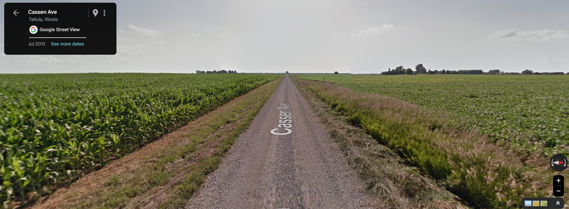
Mind you, most of these unpaved roads just look like this:
Cassen Road near Tallula would qualify as a highway in some states.
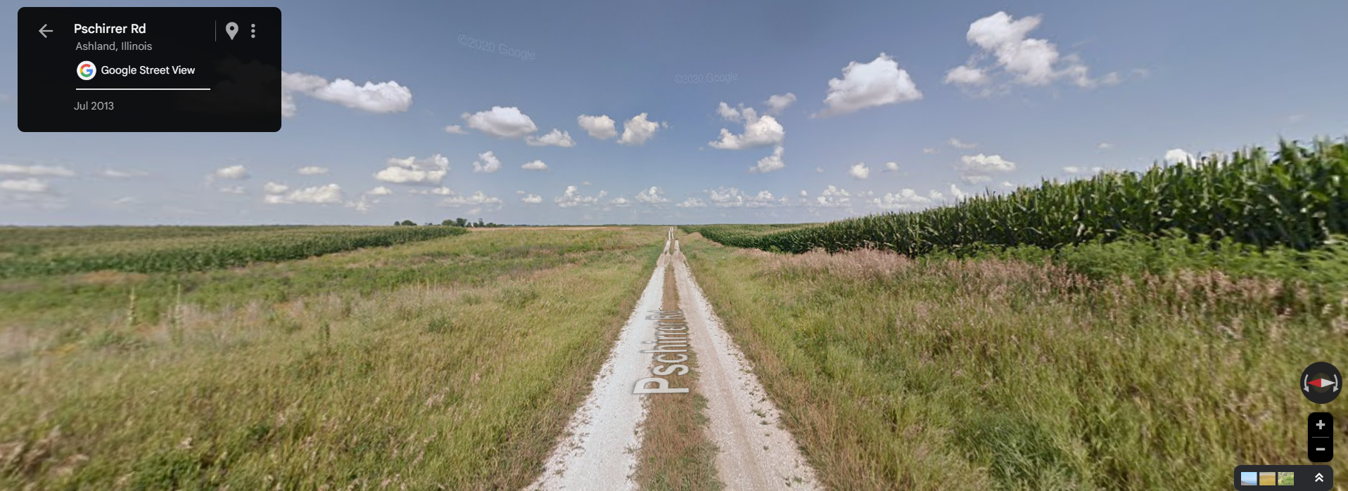
Some of the less-maintained ones look like this:
Pshirrer Road near Newmansville, is two separate strips of gravel, one for each wheel.
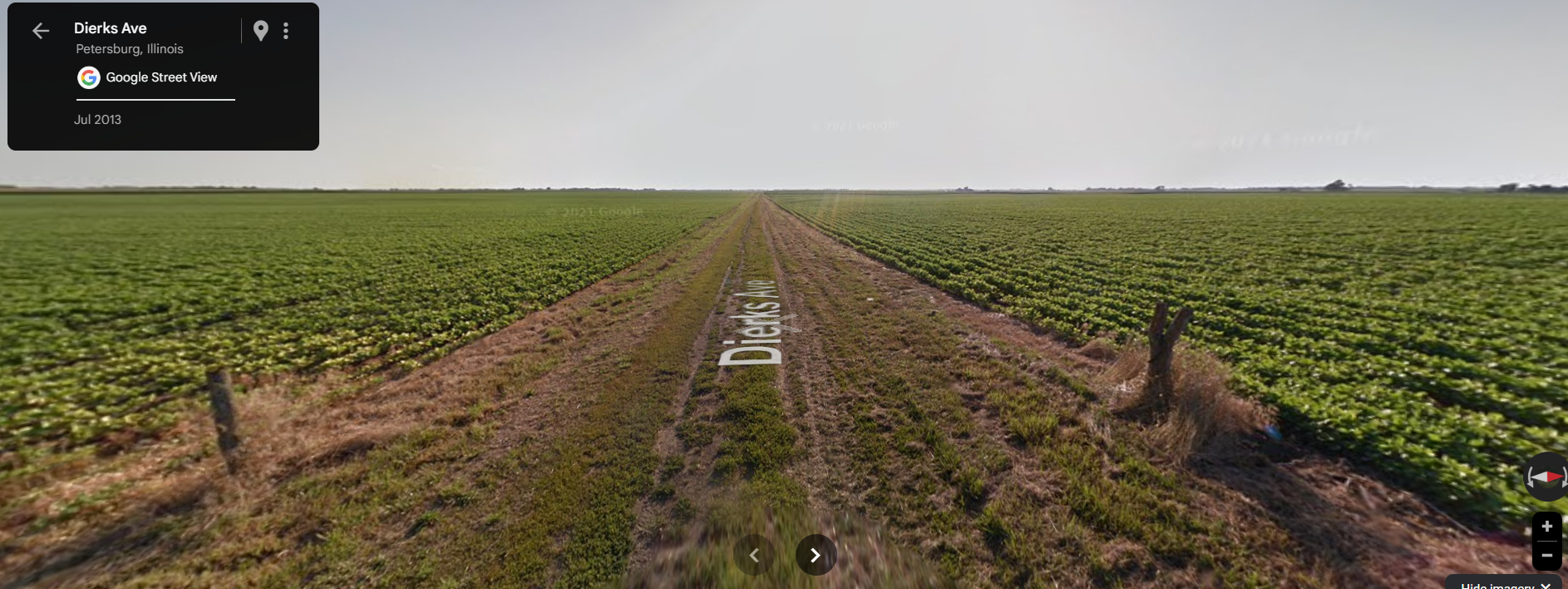
And a few have been allowed to deteriorate to this point:
Dierks Ave near Petersburg, is basically dirt in this photo. But there’s actually old gravel under there. Note it has been re-graveled since this photo and no longer looks anything like this.
But still, very flat, mostly straight, no sense of adventure in warm season weather. When it can get interesting is in winter, when counties like Cass seemingly don’t bother to snowplow these minor roads at all.
There is more variety in Pike Country, where the river bluffs provide changes of altitude, wooded locales, twistier roads. There is stuff like washouts, fallen trees on the roads, fording creeks, etc. Pike is one of the most active hunting areas in Illinois, and you see a lot of folks on ATVs on those roads.
I am not providing photographic evidence of these because one thing I learned from living in Georgia for many years is that once someone publicizes the exact location of an “interesting road” the first thing that happens is groups of people start riding convoys of 40 jeeps down it for youtube videos, and the next thing that happens is the state/county/etc paves or regrades it and takes all the fun out of it, or else closes it entirely.
This partially completed project is finally back “on track” after the final federal funding was approved in May.
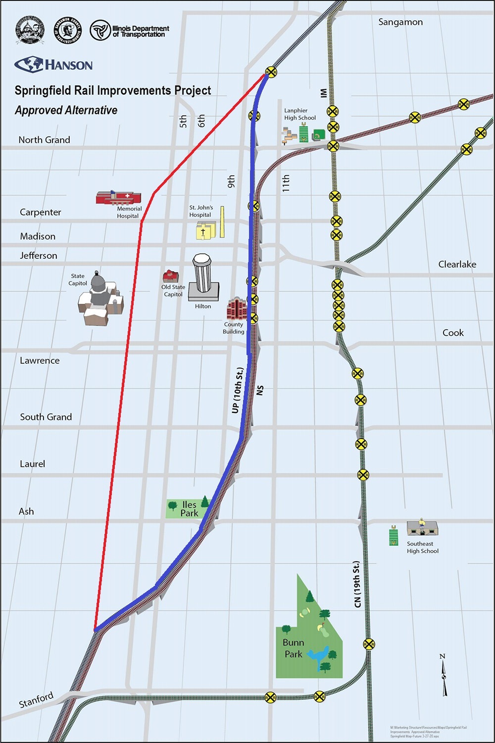
Because the official maps of the project show separate “before” and “after” maps, I’ve taken it upon myself to draw the “before” line myself onto the “after” map, I’ve taken it upon myself to create a composite using MS Paint. The red drawn line is the current UP (ex-SP, ex-ICG, ex-GM&O, ex-Alton) line that will be abandoned. The blue drawn line is the new route.
Map taken from project website, modified by me.
To date, the overpasses for the new line have been built from the south end up to and including Carpenter Street. The only sign of the planned overpass over North Grand is the fact that the McDonalds at 9th and North Grand has already been demolished for some months. The state EPA office has also moved to White Oaks Mall to make way for this construction.
From a railfan perspective, this is both good and bad. It is bad because it will move the trains 7 blocks further from my house, and also eliminate several grade crossings which can currently be used for trainwatching. It is good because it concentrates both UP and NS onto one right of way (still separate railroads, but right next to each other) for a long stretch, allowing one to “double dip”. Currently the only place that can be done is a short stretch south of town. As these are by far the roads with the most trains in Springfield, this means the vast majority of all the rail traffic in town would now go right past the new passenger station on 9th street.
No, I don’t know what they plan to do with the current line when it is abandoned. In 2022 at a community meeting I asked then-Mayor Jim Langfelder about it, and he said something about a light rail / trolley line. I did not believe it then and don’t believe it now. Downtown Springfield is too small to need a trolley to get from one place to another within it.
Plans for a 3rd Street Greenway seem more realistic, but still pretty ambitious for Springfield where, as we’ve seen, things change slowly. Anyone who was in Atlanta when the Beltline was being planned knows that these kinds of things can take much longer than expected, even in a much larger city,
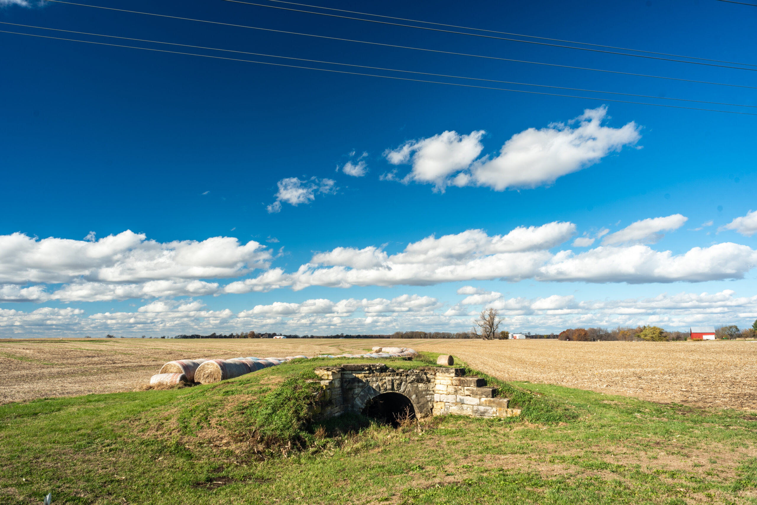
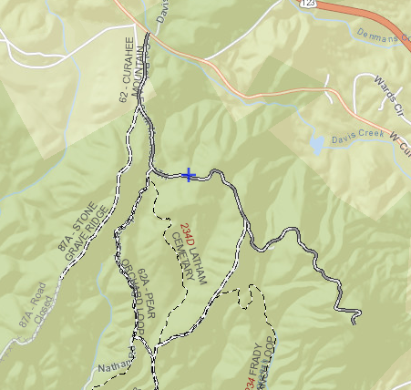
I’d been seeing this little stone arch in a field next to IL-123 for a couple years.
Not because I was looking for it, but because it’s on the way to one of closest (to me) parts of Illinois where there’s enough public dirt roads to put in the “recommended” 10 miles of 4×4 driving of a 4runner.
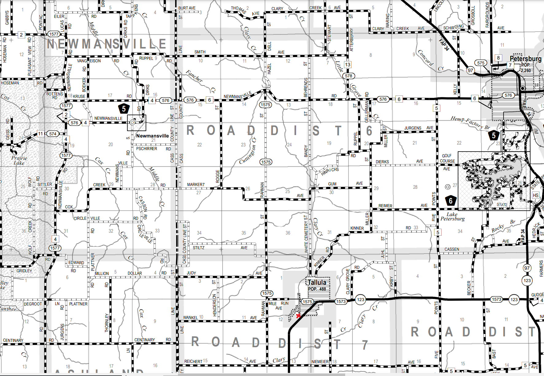
Road map stitched together in Paint from the PDFs of Cass and Menard counties, showing the abundance of unpaved gravel roads in the vicinity. The approximate location of the photo is marked with red.
Anyway, it somehow escaped me that this was in fact part of the abandoned railroad line that I already knew was in the area. I just didn’t put 2 and 2 together. Until I ran into it on Bridge Hunter, one of those last great pre-FB, pre-Twitter old school resources on the web. IMO for the (admittedly niche) subject it covers, its up there with any wiki.
The site identifies this location as:
“Abandoned stone arch bridge over Intermittent strean on Abandonded Chicago & Alton Ry”
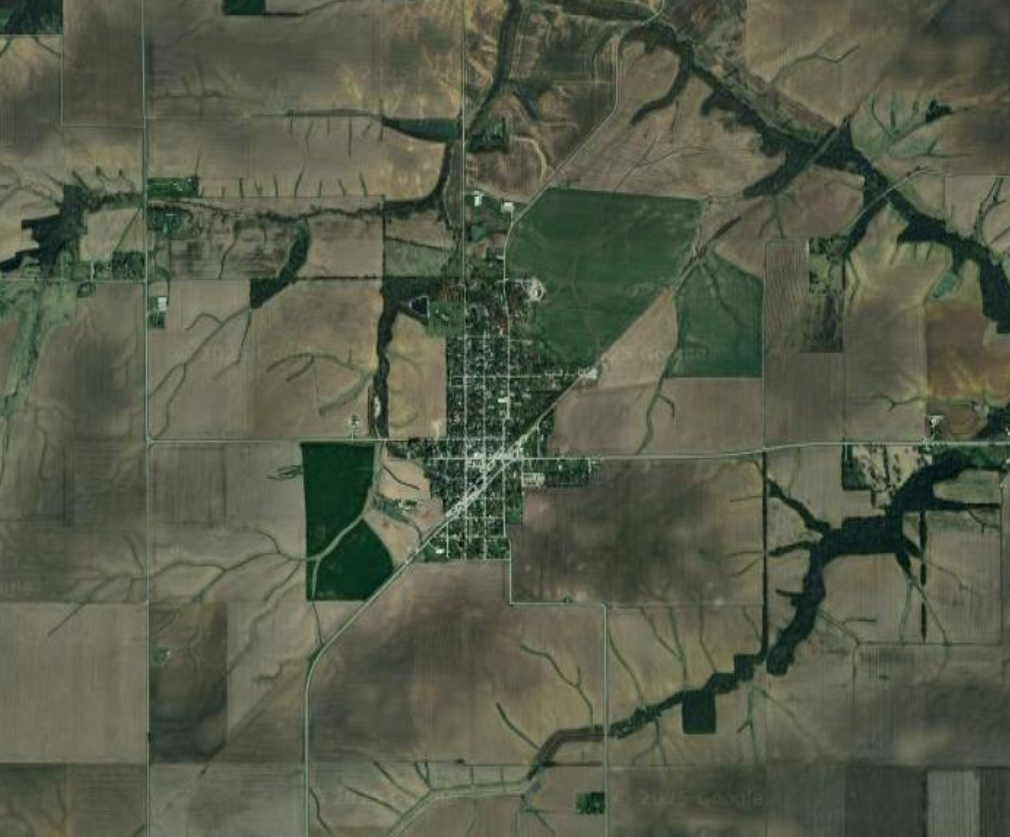
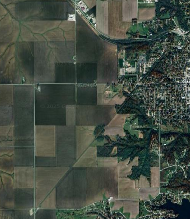
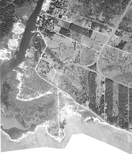
You can clearly see the “ghost line” of this railroad line on the following images. It is the line running diagonally from southwest to northeast.
Satellite image centered on Tallula, ILSatellite image centered southwest of Petersburg, IL
Info about the line on Abandoned Rails, another of those great vanishing internet resources:
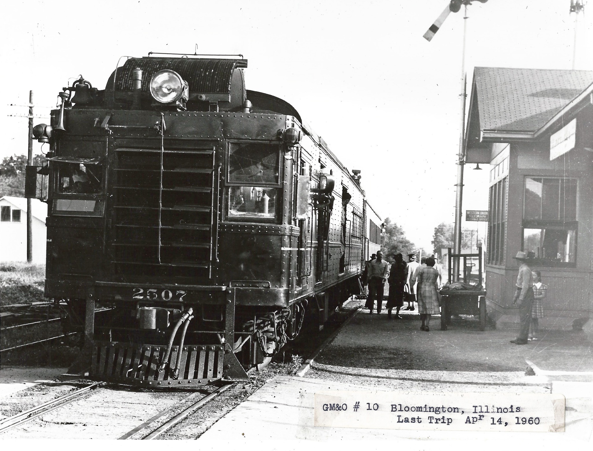
“This is the famous Jack Line that had one of the last “Doodlebug” runs untgil April 14, 1960. The double- car, motor car with trailing coach, train went daily from Bloomington, Il to Kansas City, MO and return. Trains from each direction met in Louisiana, Missouri. It was possible to make a round trip from Bloomington to Louisiana and return in a day. That was one of the longest doodlebug runs in the country and one of the latest.”
Doodlebug train from Bloomington to KC, final trip on 4/14/1960. Photo by Edward Wayne Bridges, posted to Facebook by John Woodrow on 12/6/2023.
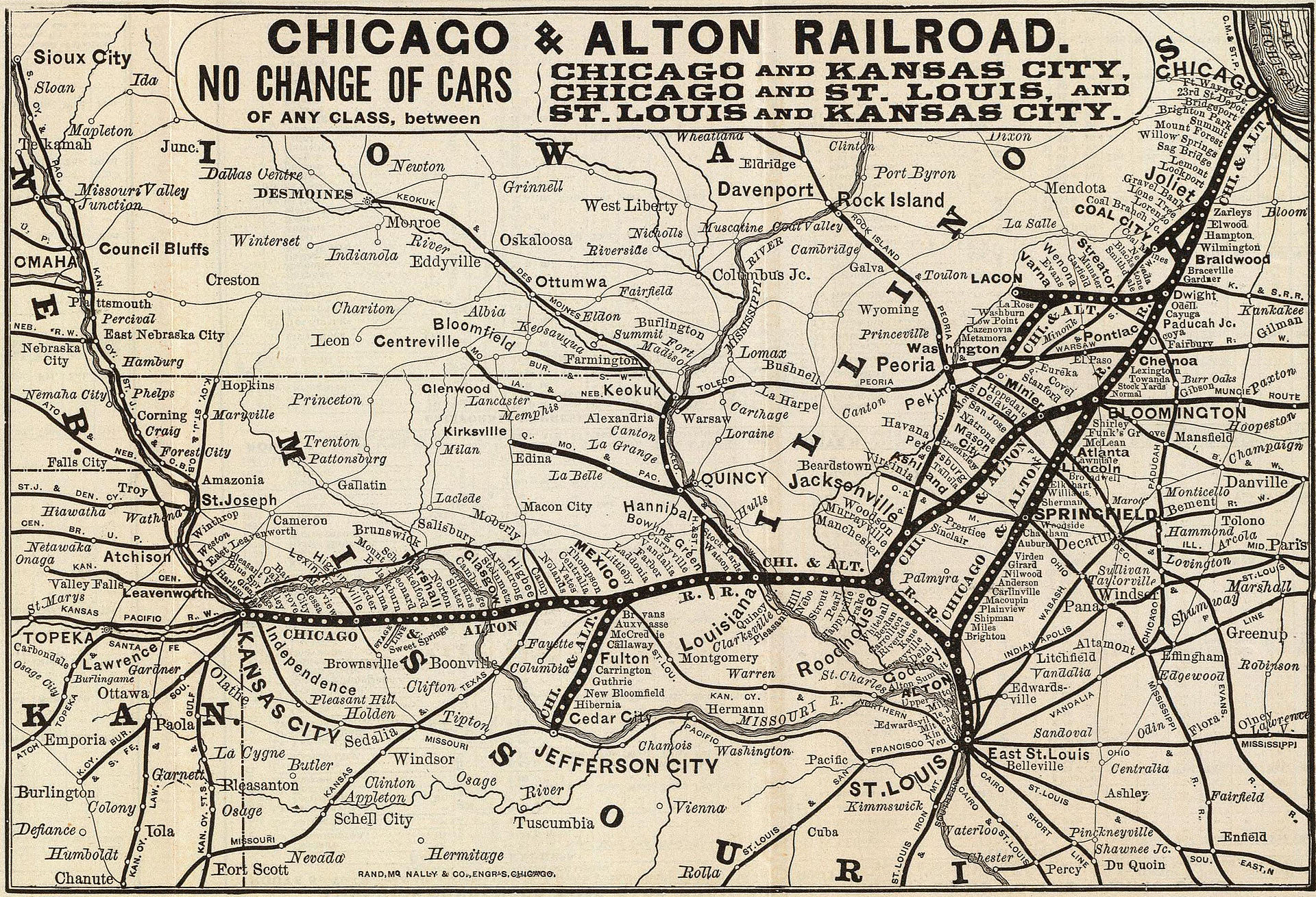
This line was the western side of a triangle that had Bloomington, Roodhouse, and Godfrey at its corners, and included Springfield along its eastern side. This can be seen on the map from the Wikipedia article on the Alton Railroad.
1885 map of the Chicago and Alton Railroad.
From the points of this triangle, lines connected to Chicago, St. Louis, and Kansas City. So while this location seems remote at present, in the railroad’s heyday it was part of the connections between the Alton’s three principal cities.
So what happened? Well, what happened to many, many midwestern and midsouthern lines. The Alton was absorbed into the GM&O in 1947, which was in turn absorbed into ICG in 1972. In the 80s, ICG spun off most of its not-originally-Illinois Central trackage. They were spun off as shortlines which were eventually purchased by other Class I railroads.
The Chicago to St. Louis main line, through Springfield, is now Union Pacific and is a very busy intermodal route and the route of the Texas Eagle.
The St. Louis to KC branch did not fare as well. It ended up as KCS, and now CPKC. It currently connects KC, St. Louis, and Springfield (via the former Alton/GM&O “air line” from Murrayville to Springfield which was built in 1907 after the map shown above). It is much lower in traffic than the other line. This was the line that, during the CP and KC merger talks, CN tried to buy to extend their ex-IC line (that currently ends south of Springfield) to Kansas City.
The third leg of the triangle, which is what we’re discussing here, was completely abandoned between Bloomington and Jacksonville.
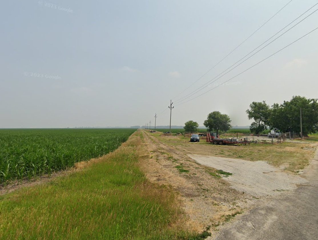
Many parts of the line are followed still by roads, power lines, or both.
Power line access road southwest of Petersburg that was once the railroad.
USGS TopoView – entry point for all current and historical topographic maps published the US government; can download maps or display them overlayed within the main viewer
Georgia Wildlife Resources Division – Interactive Map – shows state Wildlife Management Area locations, hunting, fishing, camping, shooting ranges, roads. I have learned not to trust these maps to be up to date about road closures!
MyTopo – Online Maps – these are older USGS topo maps overlayed with some such as forest service road numbers. In spite of some maps being outdated, the simple interface makes for a quick reference.
Georgia DOT Maps – Index to county road maps, which are basically the only maps online that actually show the paved or dirt status of all roads outside of national/state forests! Reasonably up to date. Unfortunate interface requires downloading individual county maps one by one.
Trails Off-Road Map – detailed trail guides for individual roads, including photos, videos, reviews. Requires sign-up with email address, facebook, etc. Some features (including to view all trails on the map at the same time) require paid membership.
Example historical map (1895) in TopoViewExample of Fed. Railroad Admin mapExample US Forest Service MapExample GA Dept. of Natural Resources MapExample MyTopo mapexample of GA DOT maps
RailGA.com was the most comprehensive site on the net for information about railroads in Georgia, until a couple of months ago when it just mysteriously went down.
Fortunately most of the pages were archived by the Wayback Machine.
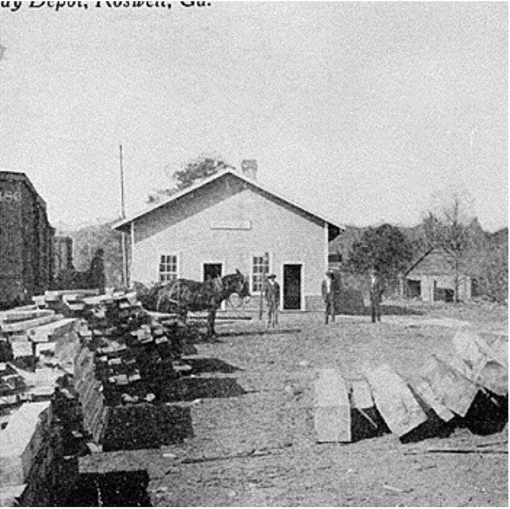
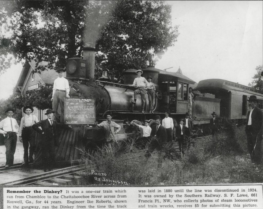
This post gathers the information I’ve been able to find about the Roswell Railroad, one of the almost-completely vanished and forgotten rail lines of the Atlanta area. This was branch of Southern Railway that operated between Chamblee and Roswell from 1881 to 1921.
The Roswell Railroad Company was incorporated in Georgia in 1879 as successor to the Atlanta & Roswell Railroad Company. It was controlled by the Atlanta & Charlotte Air-Line Railroad Company, which constructed the 10-mile, 3-foot gauge line and opened it for business on September 1, 1881. In the same year, the A&CAL was leased to the Richmond & Danville Railroad (which became Southern Railway in 1894).
The town of Chamblee was originally called “Roswell Junction”.
However, feeling the name of the settlement was too similar to nearby Roswell, they randomly selected Chamblee from a list of petitioners for the new post office name.
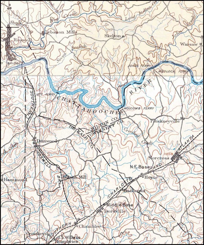
The railroad followed very roughly the present-day Chamblee-Dunwoody Road to the center of old-town Dunwoody, where the building located at 5518 Chamblee-Dunwoody Road was a section house.
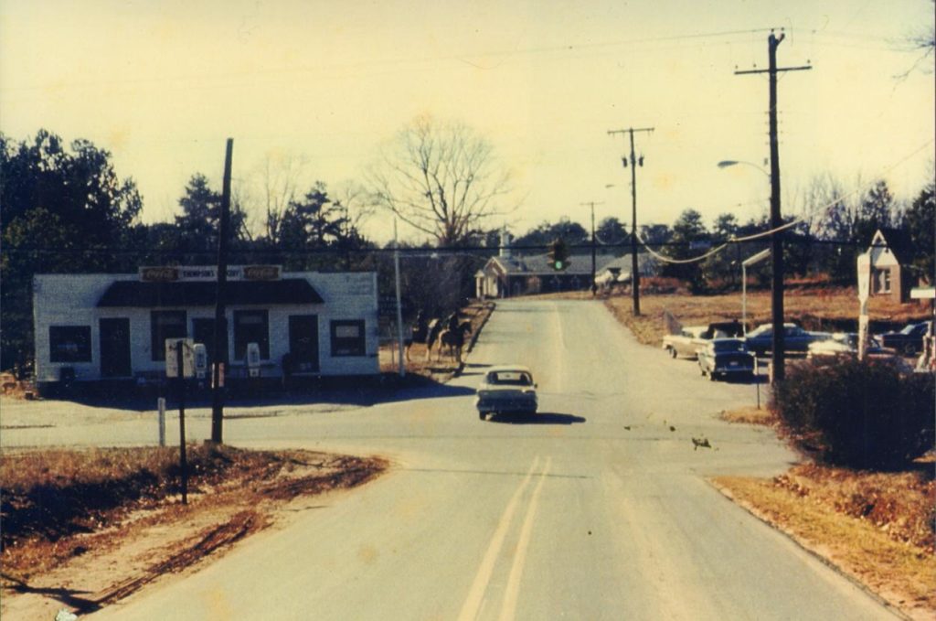
The original Dunwoody depot was later moved and used as “Thompson’s Store”, but this building no longer remains.
The line never actually reached Roswell, as the company was never able to build a bridge across the Chattahoochee. It ran along Roberts Drive and what is now Dunwoody Place, and ended near the present North River Tavern. This station was referred to as “Roswell” by the railroad. The engine house was “moved to by the river for use as a barn”.
Roberts Drive is named after Isaac “Ike” Roberts, the “only engineer of the Roswell Railroad”, whose house still stands at 9725 Roberts Drive.
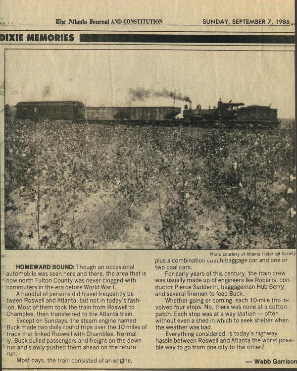
The final stop was Roswell Station, on the south bank of the Chattahoochee River, just east of the current Roswell Road. There was no means to turn the locomotive around, so it simply ran backwards on its return trip. The train was powered by 0-6-0-arranged Baldwin 1878 steam locomotive named “Buck.”
There was also a branch to the current location of Morgan Falls Dam.
The railroad famously was used by Teddy Roosevelt when he visited Bulloch Hall in 1905.
Theodore Roosevelt, who had begun his presidency on reasonably good terms for a half-northerner president, had infuriated the South by inviting Booker T. Washington to dine in the White House. Consequently, he waited a few years until the episode blew over and finally visited Bulloch Hall for the first time while touring the South in 1905. He was thought to be the first sitting President of the United States to visit the South since the end of the American Civil War, however this is incorrect as William McKinley had visited the South earlier while celebrating the victory of the Spanish–American War.
When you grow up in Bayou La Batre, there are certain things long gone that you hear about from the older residents.
The railroad. The fine hotels destroyed by the 1906 and 1916 storms, never to return. The old bridge. (Twist: I remember that one, and the old Dauphin Island bridge too!)
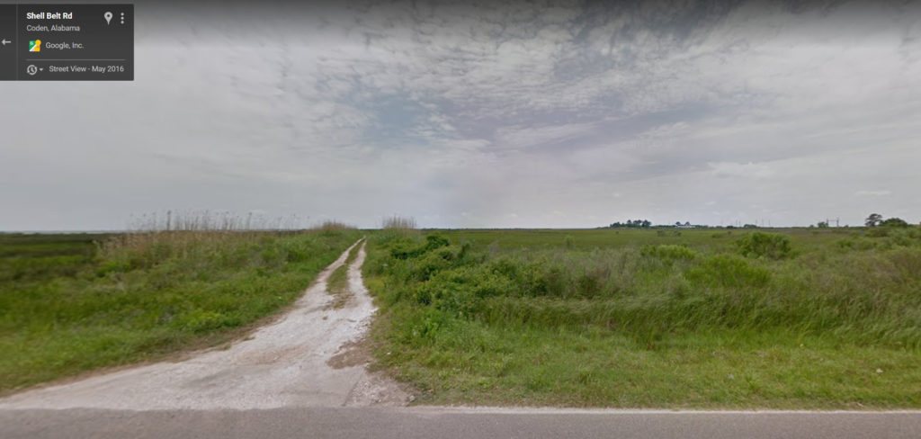
When we would drive around the shore on Shell Belt Road, my Pawpaw would point out a location where the “Old Factory” used to be. There was not even a trace of anything that looked like a building remaining.
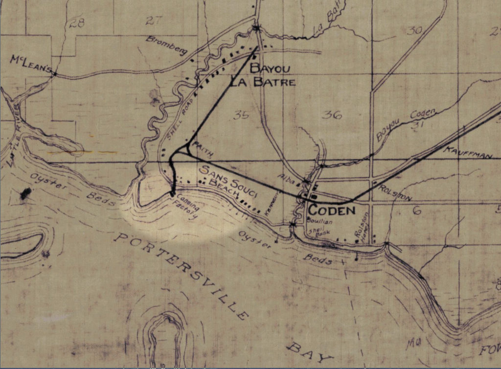
This map, dated 1918, shows a “Canning Factory” at the end of a railroad spur, located conveniently near to the “Oyster Beds”. I don’t remember anyone specifically saying that oysters were what was processed at the factory, but it would certainly make a lot of sense if it was.
The railroad here was the “Bay Shore” branch of the Mobile & Ohio Railroad, which operated from approximately 1899 to 1940. There is little to show of this line today, the rails having been physically removed soon after abandonment. It is memorialized by Railroad Street in the Bayou and Bay Shore Avenue in Mobile.
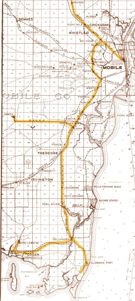
This (1926) map highlights the route from Mobile to Bayou La Batre:
At the far western end of the wye at San Souci was the lead to the Alabama Canning Company, also known as the American Canning Company. Alabama Canning Company was located on the north end of Coffee Island, about a mile south of the junction at San Souci. It was on this track that the trains would head down first, then back up through the wye toward Bayou la Batre.
The 1918 map disagrees about the factory being on Coffee Island, and I’m inclined to side with the map. An island location would have required the railroad to build a mile-long trestle over the bay. This does not fit with any description of this railroad that I’ve ever heard of before, and would have been a literal “bridge to nowhere”.
It seems more reasonable that the factory was located on the mainland.
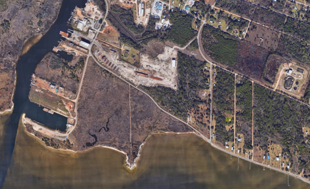
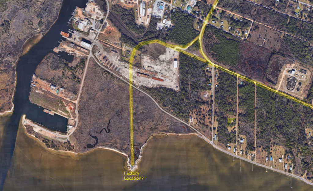
At the approximate location of where the “Old Factory” was said to be, there is still a dirt “road” off from Shell Belt Rd through the salt marsh, leading towards the shore of Portersville Bay. It goes to a point that naturally sticks out into the bay. It can clearly be seen on modern satellite images:
This is what it looks like in Google Street View (and in real life too!):
It is most consistent with the old map if this “road” is actually the railroad right-of-way. Here is the satellite image with the guessed route of the railroad tracks highlighted in yellow:
The real revelation happened when I began searching for more info on the “Alabama Canning Company”.
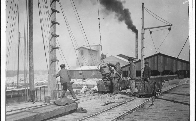
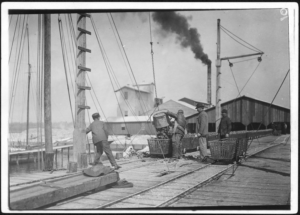
It turns out there are a lot of pictures of this place, located in the National Archives and the Library of Congress!
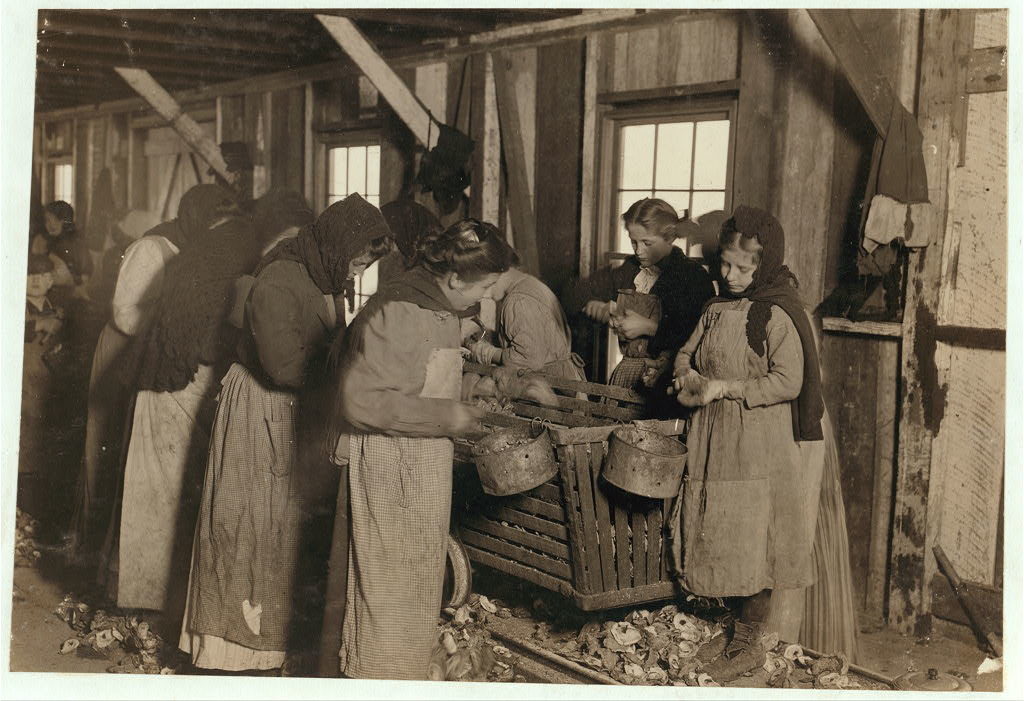
This photo shows oysters being unloaded onto the dock. It looks like they had a large pier running out into the bay, with railroad tracks utilized for wheeled oyster baskets. The factory in the background looks like a sizeable operation. It must have been the biggest industry in town at the time.
Many of the photos show very young workers in the factory and on the boats. This was the early 20th century, the era of child labor.
Original caption: “Alfred and Willie, two young oyster fishers in Mobile Bay. A few, but not many of these youngsters are found on the oyster boats. Bayou La Batre, Ala.” (National Archives)
“Fred, a young oyster fisher; working on an oyster boat in Mobile Bay, the Reef, near Bayou La Batre, said he was fourteen, but not likely. ” (Library of Congress)
“Shucking oysters in the Alabama Canning Company (Dunbar Lopez, Dukate Co.) Small boy on left end is Mike Murphy, ten years old, and from Baltimore” (LOC)
“On right-hand end is Marie —, eight years old, who shucks 6 or 7 pots of oysters a day (30 or 35 cents) at a canning company. At left end of photo is Johnnie —, eight years old, who earns 45 cents a day. Been shucking for three years. ” (LOC)
“Little Nettie [?], a regular oyster-shucker in Alabama Canning Co. She speaks no English. Note the condition of her shoes, caused by standing on the rough shells so much, a common sight”. (Other versions identify the subject as “Lottie”)These photos were taken about 1912-1913. The children would have been born in the first decade of the 20th century. This is about the age of my great-grandparents. If you are from Bayou La Batre, some of them could be your great-grandparents, if not great-great-grandparents.
The work was seasonal, with many families coming to town only during the cooler months when oysters were in season. You can see in the photos almost everyone is dressed for cooler weather. Many of the workers were also immigrants, as the captions mention some children being unable to speak English. From the Mississippi Gulf Coast Museum of Museum of Historical Photography website:
The [labor shortage] problem was resolved initially by bringing in Eastern European immigrants known as ‘Bohemians’ from the Baltimore, Maryland canneries. The Baltimore people traveled in special railroad cars from their homes in Baltimore to work the canneries during the winter oyster season along the coast. They lived in factory-owned camps near the canneries, and the children rarely attended local schools. Some of the Baltimore families stayed on after the oyster season.
We can assume the hiring practices established in Biloxi were also followed in Bayou La Batre.
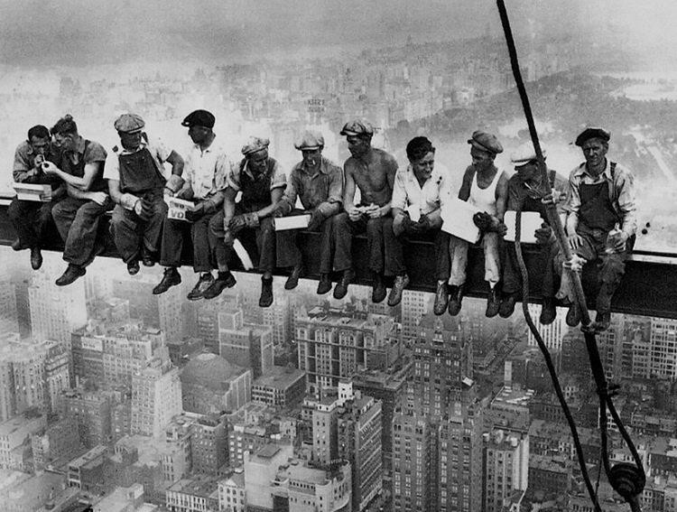
It turns out the reason all of these 100-year old pictures from Bayou La Batre are part of the national historical record, is because they were part of a famous series taken by Lewis Wickes Hine. Lewis Hine is an unsung hero of American labor relations, risking his own safety to end the practice of child labor in this country.
Lewis W. Hine
In 1908 Hine became the photographer for the National Child Labor Committee (NCLC), leaving his teaching position. Over the next decade, Hine documented child labor, with focus on the use of child labor in the Carolina Piedmont,[3] to aid the NCLC’s lobbying efforts to end the practice.[4] In 1913, he documented child laborers among cotton mill workers with a series of Francis Galton‘s composite portraits.
Hine’s work for the NCLC was often dangerous. As a photographer, he was frequently threatened with violence or even death by factory police and foremen. At the time, the immorality of child labor was meant to be hidden from the public. Photography was not only prohibited but also posed a serious threat to the industry. To gain entry to the mills, mines and factories, Hine was forced to assume many guises. At times he was a fire inspector, postcard vendor, bible salesman, or even an industrial photographer making a record of factory machinery.[5]
So here we have a connection to historical events of national importance, right there in Bayou La Batre, and all that’s left of it is a dirt path through the marsh grass and scattered recollections of an “Old Factory”.
Hine is also the photographer of a very well known series on the construction of the Empire State Building.
So when was this factory built, and whatever happened to it? The Bay Shore website says:
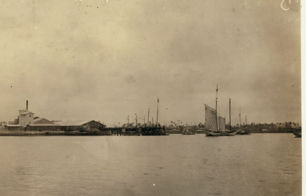
Below is a photograph taken before the hurricane of 1906, showing the company tracks on the west side of the building. The photographer is facing south, toward Portersville Bay.
The buildings seen in this image were either heavily damaged, or destroyed, in the 1906 hurricane, and the company either elected not to rebuild, or was financially unable to. At a later date (unknown) this location became the Dunbar & Ducate Factory. Dunbar & Ducate was later destroyed by a boiler explosion which claimed the lives of several employees.
“Dunbar & Ducate”, (or DuKate) had already taken over by the time of Hines’ photos in 1912-1913 (and indeed some of his captions refer to it as such).
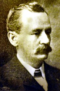
W.K.M. DuKate
The Biloxi Historical Society lists a number factories owned by several firms involving the DuKate family, including “Dunbars, Lopez, & Dukate Company“, in Alabama, Mississippi, and Louisiana. It appears that it was often called the “Alabama Canning Company” even when it was owned by DuKate.
Julian Lee Rayford, writing in 1956, describes a world already long gone, including a “Big Factory” owned by “Dunn, Barr, and Ducate”.
GEORGE BRYANT told me about the factories
in Bayou la Batre.
The factories fall into two classes. First, the
factories of 1915, and a few years later. And,
second, the factories of today. There is little con-
nection between the two. True, the factories have
always canned shrimp and oysters, but there is a
distinct contrast between the periods.
Pure Food Laws have cleaned them up, and
now, everything is peaceful and quiet in the fac-
tories. Government inspectors stand on constant vi-
gil making the pickers maintain purity and quality
in the products.
After 1906, the factories lined the Bayou.
There was the Union factory, operated by the
Union. There was the finest and largest, the one
run by Daughdrille. On the coast, was the “Big Factory,” controlled by Dun, Barr and Ducate. And
there was the “Green Factory,” so called because of
the color used on the outside of the building. All
along the Bayou were the picking sheds, which sent
their products to the larger establishments to be
packed, or, canned.
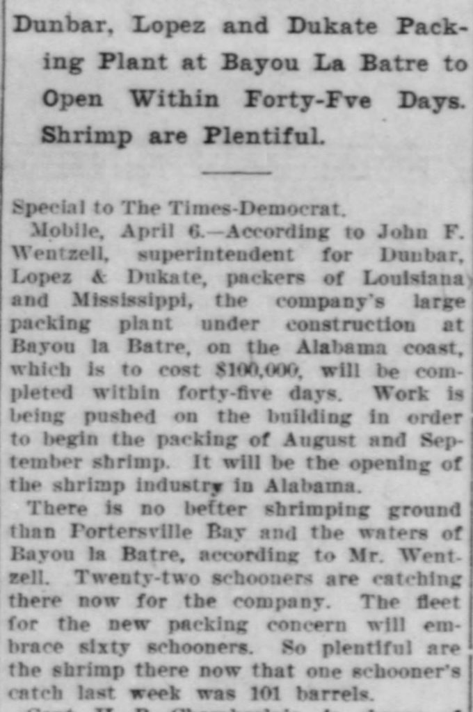
An article in the New Orleans Times-Democrat, April 7 1910, mentions a factory being constructed by this company in Bayou La Batre:
The John F. Wentzell mentioned here is probably related to Wintzell’s Oyster House founder J. Oliver Wintzell, as well as the Wintzell family of Bayou La Batre.
The factory is described as packing shrimp. It is not clear if this was the same facility as the oyster plant shown in the photos, or a different plant also located in Bayou La Batre.
I cannot find any information about the existence of the Alabama Canning Company earlier than this. It is possible it operated under a different name before DuKate took it over, if it actually existed before 1910.
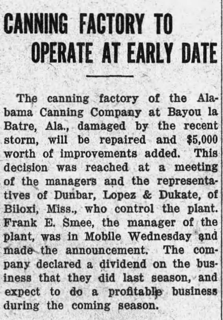
The plant survived and was repaired after the 1916 storm:
I can only find one other page about an explosion, the Find-A-Grave page for Robert Walter Cox who died on August 16, 1923 when an ammonia tank exploded in the ice plant of the cannery. It reads like a newspaper article, but there’s no citation and I cannot find the same story anywhere else.
EXPLOSION KILLS ONE AND INJURES TWO AT ICE PLANT
Ammonia Tank Blows Up At Bayou La Batre, Killing Robert Cox and Wrecking Plant
Death injury and heavy property damage resulted form a violent explosion at the ice pant of the Alabama Canning Company at Bayou la Batre Thursday night. Robert Cox, 40 years old, frieman at the plant was almost instantly killed and two other persons, Willie and Aime Castello, father and son, recieved serious injuries. The disaster occurred when an ammonia generator exploded, wrecking the one-story structure. The loud noise which accompanied the explosion attracted the attention of people throughout the community, many of whom hurried to the scene.
Cox was discovered in a dying condition outside the boiler room a few minutes after the generator exploded. The younger Castello was huried to the roof of the building from which he was rescued by persons who rushed to the plant. Willie Castello, the father, is an engineer at the plant according to information received in Mobile. His son is tankman at the ice plant.
Shortly after the accident a Mobile physicain was summoned to treat the injured. The small casualty list was apprently attributable to the fact that only a few employees were on duty whe the explosion occurred.
Perhaps this explosion was too much for the Big Factory to come back from, and put them out of business. Perhaps the Pure Food and Child Labor laws had made the business unprofitable. Or maybe decreasing supply due to overfishing. Or a combination of all these things.
By the time of this 1943 map, the railroad is abandoned, the spur track for the factory is already just a dirt road, and the there is no indication building where the factory would have been.
I actually hesitated to get to specific about where I was sitting when watching trains here for a while, because I’m still not entirely sure if you are supposed to be there or not. Whatever. Only my friends read this blog (and probably not even most of them), and I’ve already admitted to creeping around on property that was closed off due to “terrorism” threats..
First, a map. To find this area on Google maps, use these directions. Click on this image here to expand this map.
Now, this map shows several ways you can observe trains in this area, which I will explain here in no particular order.
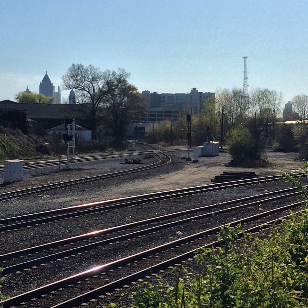
Marietta Street Bridge – you will need to park somewhere near the bridge, and walk to it. There are times when such parking will be difficult to find. It provides an overhead view of both railroads’ lines headed downtown.
Foster Street – the street crosses the NS tracks and ends. There’s not a clear indication of where the street technically ends and where the railroads’ access roads begin. The crossing of NS is marked with a crossbuck as seen on all public road crossings. I’m fairly certain once you get to the CSX tracks, it’s railroad property. The area in between, seems like it would have to be either NS or CSX property. I have sat parked here without being run off, but YMMV.
10th Street – there is a parking lot at the end of the street that never has any vehicles parked in it. There are “no parking/tow away” signs, but it seems to be fine for sitting in or near the car and observing trains. You are right next to the CSX. I have no idea whose parking lot this is. There is a chainlink fence between the parking lot and the tracks, but the gate is normally open and used by the railroads.
King Plow Parking Lot – this provides a view of the area where the two railroads’ wyes are closest to each other. There is a guard tower in this lot and a sign saying it is for King Plow use only, but I have never been messed with while parking here and sitting in the car to watch trains. You will be watching trains through a fence though. From here you can see the NS basically right across the fence, and CSX a little ways beyond that.
Bim’s Liqour Store – they clearly understand that their customers want to sit out behind the store by the tracks, because there is a picnic table back there and everything. So if you are not the kind of person who is bothered by the idea of hanging out at a liquor store, this is a good place to watch trains. Buy something from the store since you are on their property after all.
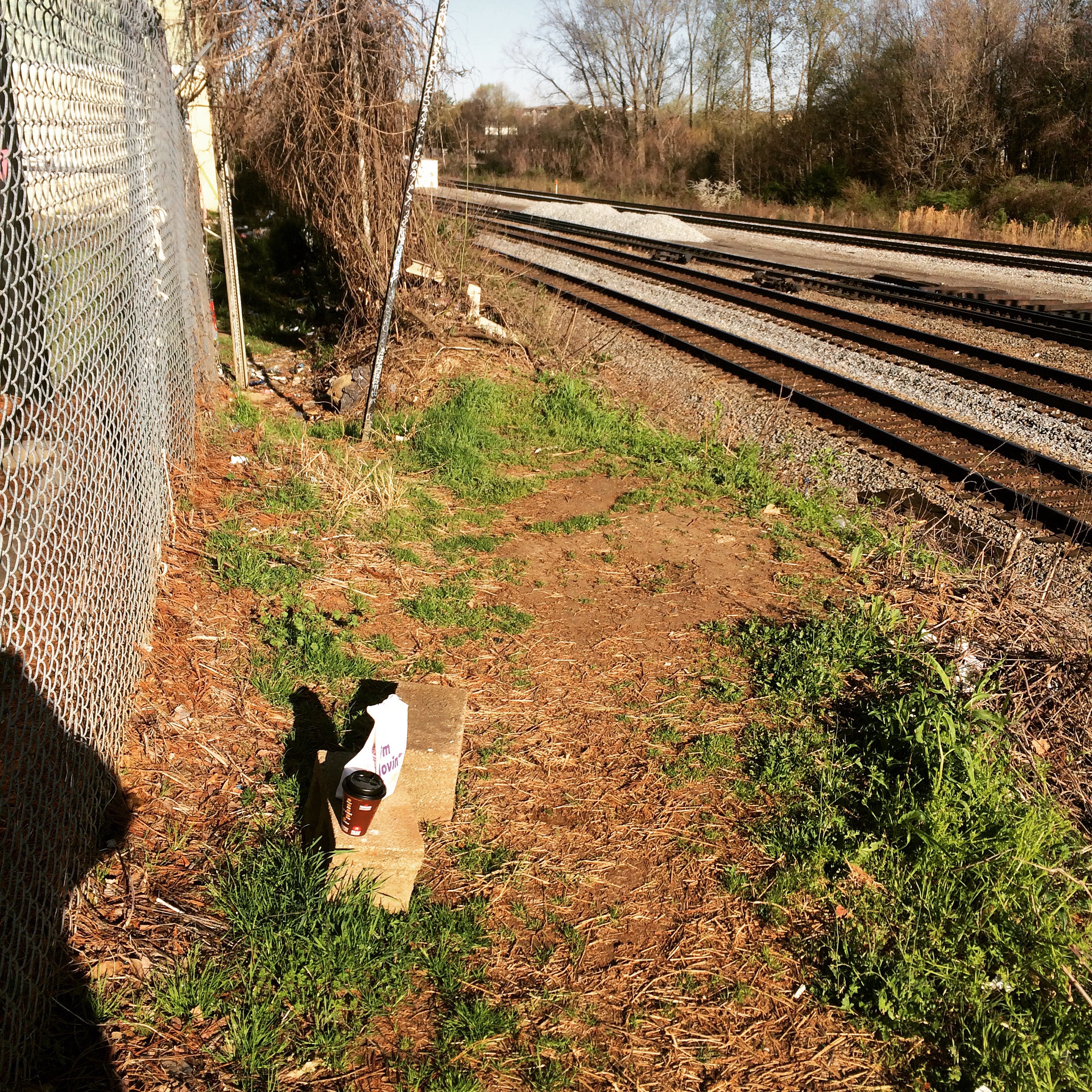
Ye Olde Hole in the Fence – this is “it”. This provides basically the same view as the King Plow Parking lot, only you are now on the track side of the fence. The legality of this is… uncertain, but railfans go back there all the time just judging by the amount of photos and videos you see taken from back there. To get here, walk to the northeast corner of the parking lot of the vacant building to the east of Bim’s, which I believe was once a porn shop. There is a break in the fence right at the corner, that you can go through and make your way along a dirt path worn between the tracks and the fence. There is no picnic table, but there are some cinder blocks that can be used for sitting. I suggest bringing your own portable chair.
Now, some photos.
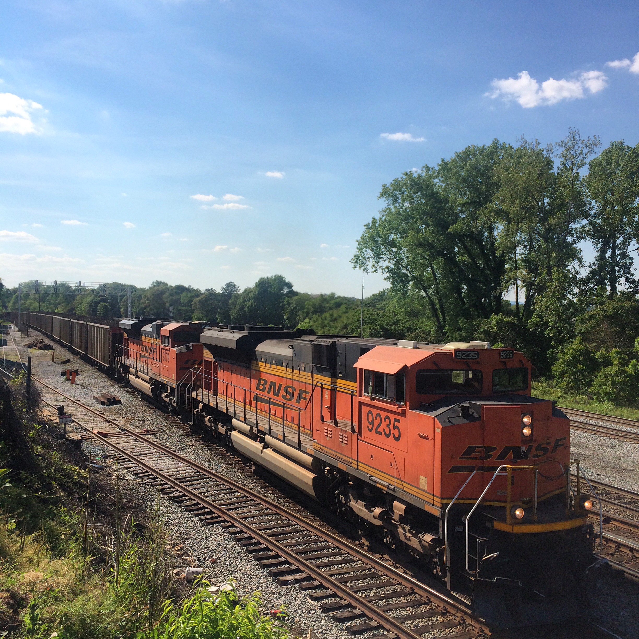
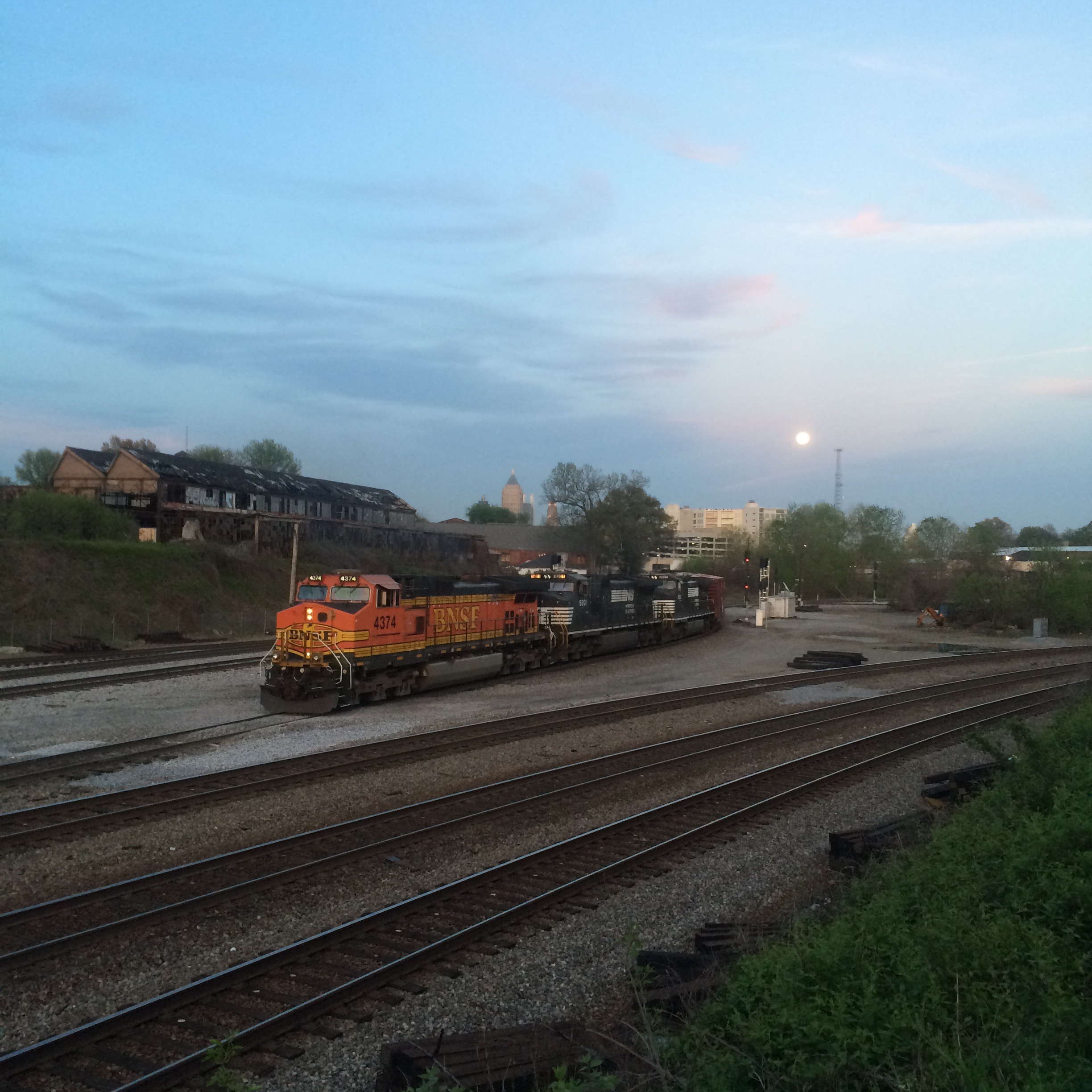
BNSF run-powered coal train on NS, I think train 734 or maybe 732, seen from the area behind the liquor store:
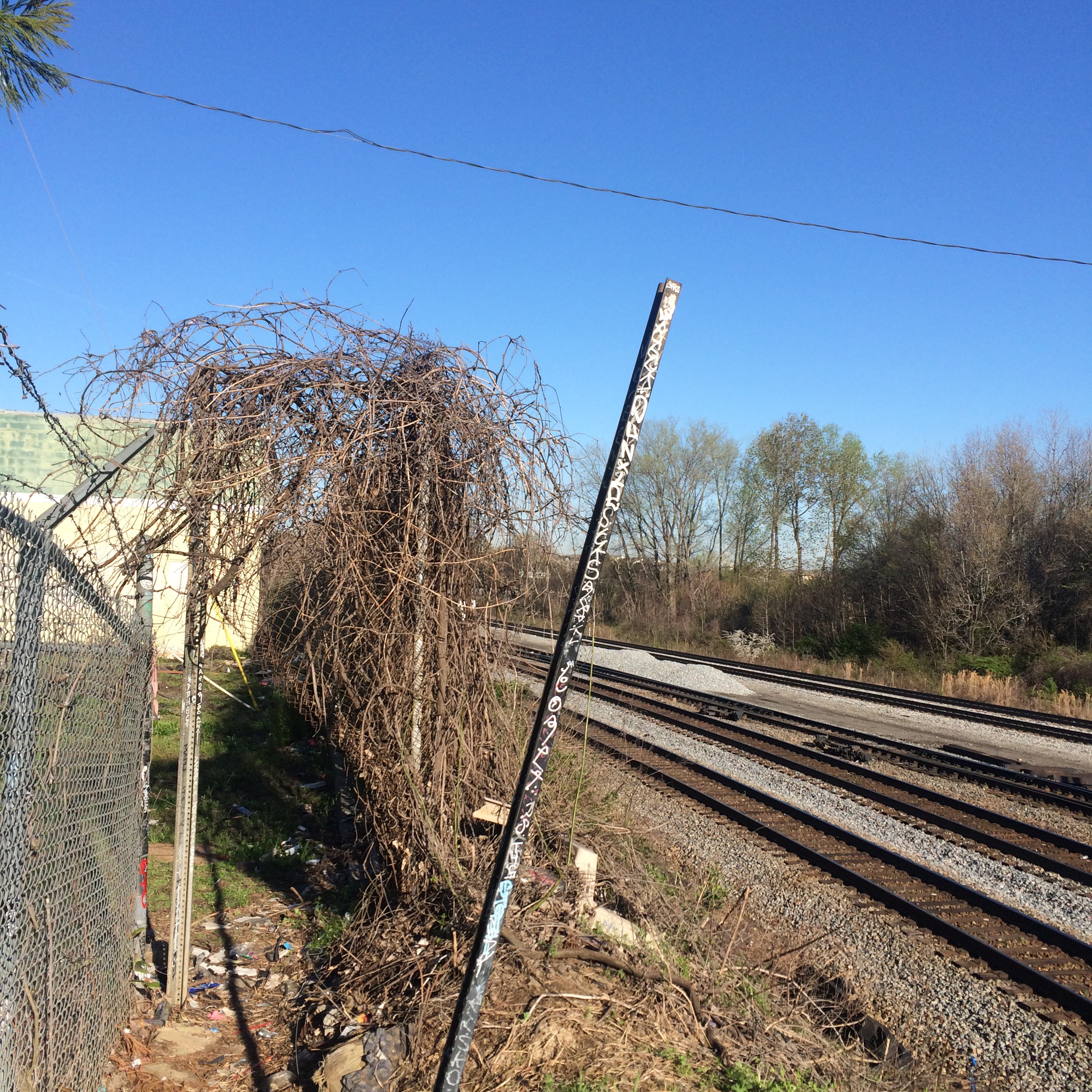
Now, about that hole in the fence. Recyled from an earlier post, this is what the hole itself looks like from the “beyond the fence” side:
These are the cinder blocks mentioned:
From back there you can clearly see one of the diamonds where the NS crosses the CSX main line:
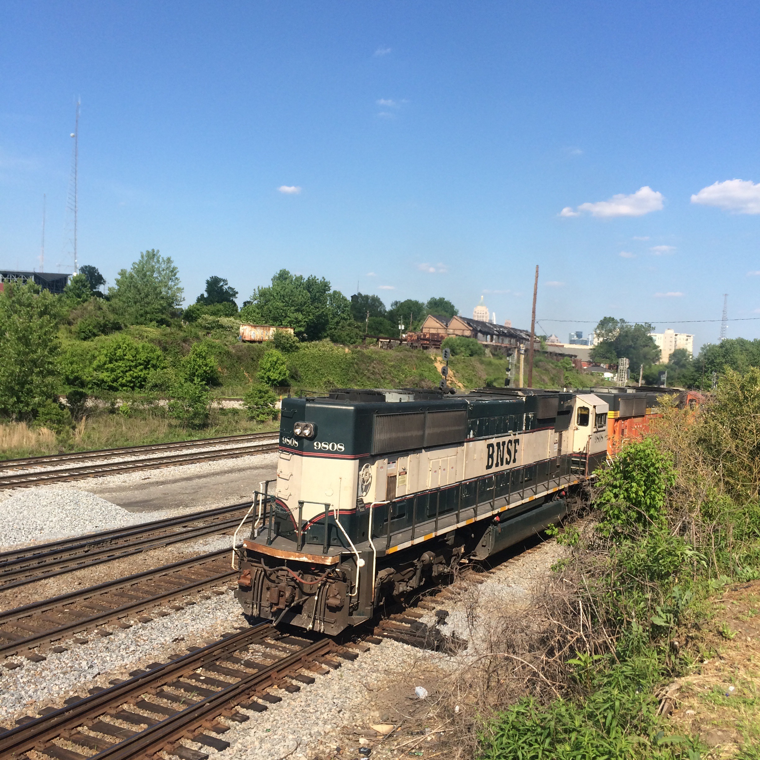
Here’s a pic of a train going through that diamond:
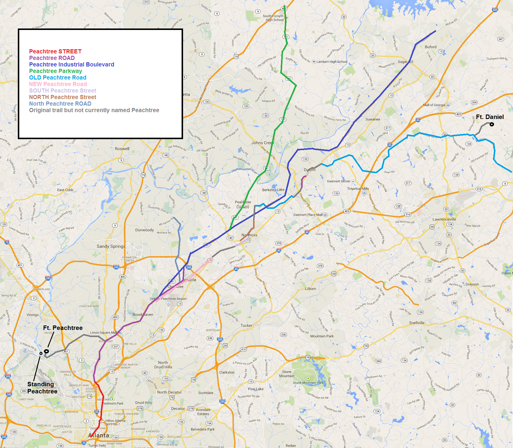
Not shown: West Peachtree Street, Peachtree Battle Avenue, Peachtree Corners Circle, and a million more. Boundary between Peachtree Street and Peachtree road is guesswork and probably wrong. The city makes no real distinction between them. The boundary has something to do with where the city limits were and/or where the pavement gave way to dirt, at some arbitary time in the past.
I think this might be the only map like this around; I would not have bothered to make it if I could have found one.
For Non-Atlanta people, when someone says “Peachtree” with no other qualifier, they mean Peachtree Street or Peachtree Road from downtown northward to the point where Peachtree Industrial Boulevard begins. Anything else requires more information to differentiate what you mean. (Those are also the only Peachtrees that are considered important, at least by people who live ITP. The others are just curiously named extensions)
Don’t get worked up about the blocky lines or inexactness. I made this thing in MS Paint for crying out loud.

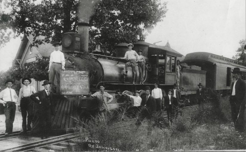

 The final stop was Roswell Station, on the south bank of the Chattahoochee River, just east of the current Roswell Road. There was no means to turn the locomotive around, so it simply ran backwards on its return trip. The train was powered by 0-6-0-arranged Baldwin 1878 steam locomotive named “Buck.”
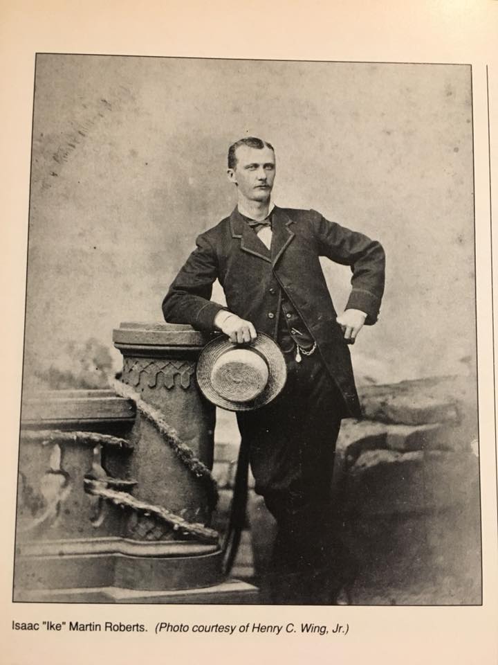


